Filter: COLLECTION_NAME of Rodolf family collection, 1833-1840

| Date: | 1833 |
|---|---|
| Description: | Township/section map showing Rodolf land and nearby neighbors. |
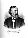
| Date: | 1881 |
|---|---|
| Description: | Quarter-length engraving of Colonel Theodor C. Rodolf. |

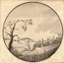
| Date: | 1834 |
|---|---|
| Description: | Peck-a-ton-oka (Pecatonica River) with Rodolf farm in the background. |

| Date: | 1840 |
|---|---|
| Description: | A hand-drawn plat map of Mineral Point, Wisconsin showing street layout and location of buildings. |
| Date: | 1838 |
|---|---|
| Description: | Pencil sketch of a building owned by the Rodolf family along a commercial street. |
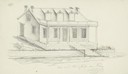
| Date: | 1838 |
|---|---|
| Description: | Pencil sketch of a stone house with a porch the full length of the dwelling, supported by 6 columns. |
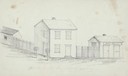
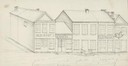
| Date: | 1838 |
|---|---|
| Description: | Pencil sketch of buildings, including the Post Office. |

| Date: | 1840 |
|---|---|
| Description: | Photograph of a drawing of an Indian aiming his bow and arrow, with one foot standing on an earlier kill. |
If you didn't find the material you searched for, our Library Reference Staff can help.
Call our reference desk at 608-264-6535 or email us at: