 Filter: Categories of Wisconsin Historical Images
Filter: Year of 1700-1799
Filter: Categories of Wisconsin Historical Images
Filter: Year of 1700-1799

| Date: | 1744 |
|---|---|
| Description: | Paris: 1744. W 92⁰--W 76⁰/N 49⁰--N 41⁰. Scale [ca. 1:4,000,000] |

| Date: | 1757 |
|---|---|
| Description: | The Canadian Lakes. Scale [ca. 1:6,500,000]. Paris: 1757. |
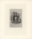
| Date: | 1774 |
|---|---|
| Description: | Engraved portrait of Samuel Adams, a Founding Father of the United States and 4th Governor of Massachusetts (1792-1794). Adams' portrait is framed in an ov... |
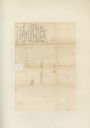
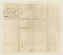
| Date: | 06 22 1774 |
|---|---|
| Description: | The address page of a letter written by Col. William Christian to Col. William Preston. There is a note on the right side: "Surveyors out. Suggests sending... |
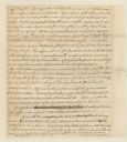
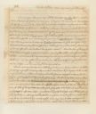
| Date: | 06 21 1774 |
|---|---|
| Description: | Page two of a letter written by William Christian to Col. William Preston. From Preston and Virginia Papers [Calendar series Volume 1]: "Dunkard Bot... |
| Date: | 1780 |
|---|---|
| Description: | A letter written to William Preston. From Preston and Virginia Papers [Calendar series Volume 1]: "List of officers and number of men in their compa... |

| Date: | 06 22 1780 |
|---|---|
| Description: | A letter written by (illegible first name) Peterson to Michael Price in the 1700s. |

| Date: | 06 21 1780 |
|---|---|
| Description: | The address page of a letter written by Peterson to Michael Price. |
| Date: | 04 24 1779 |
|---|---|
| Description: | A statement written by William Preston. From Preston and Virginia Papers [Calendar series Volume 1]: "Statement acquitting George Patterson of the c... |

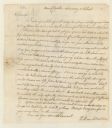
| Date: | 12 17 1756 |
|---|---|
| Description: | The second page of a letter written by William Fleming to William Preston. From Preston and Virginia Papers [Calendar series Volume 1]: "Vause's [Fo... |

| Date: | 1756 |
|---|---|
| Description: | The address page of a letter written by William Fleming to William Preston. |

| Date: | 09 13 1763 |
|---|---|
| Description: | A letter written by William Ingles to William Preston. |
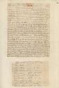
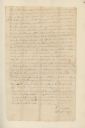
| Date: | 06 20 1774 |
|---|---|
| Description: | Page one of a letter written by William Christian to Col. William Preston. From Preston and Virginia Papers [Calendar series Volume 1]: "Dunkard Bot... |
| Date: | 06 22 1774 |
|---|---|
| Description: | The back of a one page letter written from New Dublin by William Christian to Col. William Preston. |
| Date: | 06 22 1774 |
|---|---|
| Description: | A letter from New Dublin written by William Christian to Col. William Preston. |
| Date: | 05 28 1779 |
|---|---|
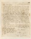
| Description: | Letter written by John Monture to John Dodge. |

| Date: | 1719 |
|---|---|
| Description: | Map of Maryland and surrounding states. It shows the boundaries, counties, cities, towns, rivers, and bays. Mountains, forests, and swamps appear pictoria... |

| Date: | 1795 |
|---|---|
| Description: | Map of Connecticut showing counties, townships, cities, roads, islands, swamps, hills, mountains, lakes, rivers, reefs, and numerous other geographical and... |

| Date: | 1758 |
|---|---|
| Description: | Map of Rhode Island and Connecticut, showing counties, townships, cities, roads, islands, mountains, lakes and rivers. Trees and a frame decorates the titl... |

| Date: | 1795 |
|---|---|
| Description: | Map of Rhode Island showing counties, townships, cities, roads, mountains, swamps, islands, reefs, lakes and rivers. Several of the bigger cities include s... |
If you didn't find the material you searched for, our Library Reference Staff can help.
Call our reference desk at 608-264-6535 or email us at: