 Filter: Categories of Wisconsin Historical Images
Filter: State of North Carolina
Filter: Year of 1800-1899
Filter: Categories of Wisconsin Historical Images
Filter: State of North Carolina
Filter: Year of 1800-1899
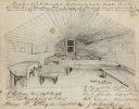
| Date: | 08 08 1862 |
|---|---|
| Description: | Contemporary drawing of the interior of a prison barracks. Quarters of I.D. Cruttenden, Captain and Assistant Quarter Master of the "W.I.V." (Likely signif... |

| Date: | 1865 |
|---|---|
| Description: | This map is a pen and ink tracing. Union positions are shown in blue and Confederate positions are shown in red. Roads, vegetation, and streams are labeled... |

| Date: | 1865 |
|---|---|
| Description: | This map of the Bentonville, N.C., battlefield illustrates the positions of the Union and the Confederate troops, roads, rivers, vegetation, and the names ... |

| Date: | 1865 |
|---|---|
| Description: | This map illustrates the lines of defense established by Confederate troops, under the command of General Joseph E. Johnston, at Raleigh, North Carolina, i... |
If you didn't find the material you searched for, our Library Reference Staff can help.
Call our reference desk at 608-264-6535 or email us at: