 Filter: Categories of Wisconsin Historical Images
Filter: State of Kentucky
Filter: Categories of Wisconsin Historical Images
Filter: State of Kentucky
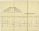
| Date: | 02 15 1830 |
|---|---|
| Description: | Increase Lapham's drawing of a railroad tunnel and railroad tracks. |

| Date: | 1831 |
|---|---|
| Description: | Map of the city of Louisville, Kentucky on the Ohio River showing streets and numbered lots. The Ohio River, Corn Island, and the Louisville and Portland C... |
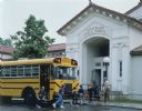
| Date: | 1990 |
|---|---|
| Description: | Color photo of a group of Cub Scouts and their scout leader exiting an International school bus and entering the Anchorage Public School. A woman is drivin... |

| Date: | 1990 |
|---|---|
| Description: | Group of Brownie Girl Scouts and their leader are posing next to an International school bus at the Louisville zoo. In the background zookeepers and childr... |

| Date: | 1828 |
|---|---|
| Description: | Map of the Louisville and Portland Canal on the Ohio River. The map shows Louisville, Shippingsport, Clarksville, Jeffersonville, Gravel Island, Corn Islan... |

| Date: | 09 11 1956 |
|---|---|
| Description: | African-American students escorted from Sturgis High School by armed National Guardsmen. |
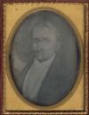
| Date: | 1850 |
|---|---|
| Description: | Quarter plate daguerreotype of a painting of Bland Ballard (1761-1853). Ballard was a noted Kentucky pioneer, and also served as a scout for General George... |

| Date: | |
|---|---|
| Description: | Sarah Harder speaking at Midway College for a daylong event titled "Report from Nairobi." Ms. Harder was an advocate for equal rights. |
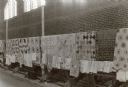
| Date: | |
|---|---|
| Description: | Quilts on display at Benham. Benham, Kentucky was a "company town" created by International Harvester for the workers employed in the mines of its subsidia... |

| Date: | 1784 |
|---|---|
| Description: | Map showing fifty thousand acres of land in what will later become Kentucky, broken up into parcels labeled 1 through 50. No features are labeled, but the ... |

| Date: | 1795 |
|---|---|
| Description: | Detailed map of Kentucky and most of Tennessee. The map shows the borders, counties, cities, towns, Native American towns, forts, roads, mountains, lakes, ... |

| Date: | 1795 |
|---|---|
| Description: | Detailed map of Kentucky showing counties, cities, towns, Native American towns, forts, salt licks, roads, prairies, mountains, lakes, and rivers. Numerous... |

| Date: | 1793 |
|---|---|
| Description: | Detailed topographical map of the Ohio River between Clarkville and Louisville. It shows plots of farmland, forest, islands, garden plots, houses, Fort Fe... |

| Date: | 07 1962 |
|---|---|
| Description: | Lewis Arms is standing next to an army tank in Fort Knox, Kentucky. He is wearing a military uniform and helmet. Three men are standing and sitting on top ... |

| Date: | 08 1962 |
|---|---|
| Description: | Lewis Arms and other men preparing chow outdoors at an Army post at Fort Knox. |

| Date: | 1950 |
|---|---|
| Description: | Subject: "I-4 — Road Building." Where Taken: "SE." Information with photograph reads: "I-4 used with Blaw Knox TRO-112 Tamping roller owned by R.B. Tyler C... |

| Date: | 1950 |
|---|---|
| Description: | Subject: "I-4 — Road Building." Where Taken: "SE." Information with photograph reads: "I-4 used with Blaw Knox TRO-112 Tamping roller owned by R.B. Tyler C... |

| Date: | |
|---|---|
| Description: | Exterior view of the entrance to a hotel and a gun store. Two people are sitting under the portico. A replica of a bomb is hanging from a pole near the ent... |

| Date: | 1960 |
|---|---|
| Description: | Forward Real Axle parts (disassembled) displayed against a white background. |

| Date: | 1960 |
|---|---|
| Description: | Sheet metal parts displayed on a pegboard. The sign above reads: "International Harvester Co. Supplier of Quality Sheet Metal Parts." |
If you didn't find the material you searched for, our Library Reference Staff can help.
Call our reference desk at 608-264-6535 or email us at: