 Filter: Categories of Wisconsin Historical Images
Filter: State of Kentucky
Filter: Creator Name of Lapham, Increase Allen
Filter: Categories of Wisconsin Historical Images
Filter: State of Kentucky
Filter: Creator Name of Lapham, Increase Allen

| Date: | 1828 |
|---|---|
| Description: | Drawing by Increase Lapham showing the geological profile of the land between Utica and Knob Creek, Kentucky at a scale of 1/2 inch to a mile. |
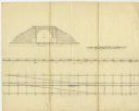
| Date: | 02 15 1830 |
|---|---|
| Description: | Increase Lapham's drawing of a railroad tunnel and railroad tracks. |

| Date: | 1828 |
|---|---|
| Description: | Map of the Louisville and Portland Canal on the Ohio River. The map shows Louisville, Shippingsport, Clarksville, Jeffersonville, Gravel Island, Corn Islan... |
If you didn't find the material you searched for, our Library Reference Staff can help.
Call our reference desk at 608-264-6535 or email us at: