 Filter: Categories of Wisconsin Historical Images
Filter: Subject of african americans
Filter: Type of Map or Atlas
Filter: Categories of Wisconsin Historical Images
Filter: Subject of african americans
Filter: Type of Map or Atlas
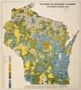
| Date: | 1940 |
|---|---|
| Description: | Map of the people of Wisconsin according to ethnic stocks. |

| Date: | 1960 |
|---|---|
| Description: | A hand-drawn map showing the "Negro Percentage of Each County's Population" in Mississippi. |
| Date: | 1947 |
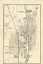
|---|---|
| Description: | This map of Racine has labeled streets, the Root River, Lake Michigan, and includes manuscript annotations of newly annexed areas and African-American neig... |

| Date: | 1946 |
|---|---|
| Description: | This map shows scenes from America's history with names of historical events superimposed on a map of the United States. |

| Date: | 1783 |
|---|---|
| Description: | This map is hand-colored and shows the boundaries of British, Spanish, and the newly recognized American claims, as well as the fishing rights granted to F... |

| Date: | 1755 |
|---|---|
| Description: | Map of Virginia and parts of Maryland, North Carolina, and New Jersey. It shows borders, boundary lines, some Native American land, counties, cities, towns... |
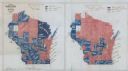
| Date: | 1900 |
|---|---|
| Description: | Hand-drawn and colored maps of Wisconsin showing how each county voted in the gubernatorial race of 1865, and on a referendum regarding suffrage for Africa... |
If you didn't find the material you searched for, our Library Reference Staff can help.
Call our reference desk at 608-264-6535 or email us at: