 Filter: Categories of Wisconsin Historical Images
Filter: Subject of Young Men's Christian associations
Filter: Type of Map or Atlas
Filter: Categories of Wisconsin Historical Images
Filter: Subject of Young Men's Christian associations
Filter: Type of Map or Atlas
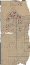
| Date: | 1918 |
|---|---|
| Description: | This World War I era map fragment depicting the western portion of Douglas County, Wisconsin, includes manuscript annotations and stickers pasted onto the ... |

| Date: | 1908 |
|---|---|
| Description: | A detail of a Madison Sanborn map that includes the University of Wisconsin Boat House, UW Gymnasium & Armory (The Red Gym), fraternity houses, and the YMC... |

| Date: | 1909 |
|---|---|
| Description: | Bird's-eye view of Lake Geneva from the south extending to Waukesha and Milwaukee in the north. Delavan Lake and Lake Como are identified. Several electric... |
If you didn't find the material you searched for, our Library Reference Staff can help.
Call our reference desk at 608-264-6535 or email us at: