 Filter: Categories of Wisconsin Historical Images
Filter: Subject of Writing
Filter: County of Grant
Filter: Categories of Wisconsin Historical Images
Filter: Subject of Writing
Filter: County of Grant
| Date: | |
|---|---|
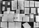
| Description: | Display of student work including drawings, maps, and essays. |

| Date: | 1848 |
|---|---|
| Description: | Pen-and-ink on paper. Includes certifications signed by "Geo R. Bluntz, District Survey of Grant Co. W.T." and Ben C. Eastman. |

| Date: | 06 1845 |
|---|---|
| Description: | This map is pen-and-ink on paper and shows the numbers, dimensions, and acreages of lots, as well as survey monuments and streets. Also included is a certi... |
If you didn't find the material you searched for, our Library Reference Staff can help.
Call our reference desk at 608-264-6535 or email us at: