 Filter: Categories of Wisconsin Historical Images
Filter: Subject of Work
Filter: Subject of mississippi river
Filter: Categories of Wisconsin Historical Images
Filter: Subject of Work
Filter: Subject of mississippi river
| Date: | |
|---|---|
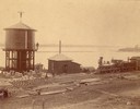
| Description: | Train station with several men, including one standing atop a large water tower. |
| Date: | |
|---|---|
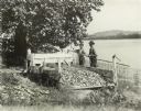
| Description: | Two men stand on the banks of a river near a mussel fishery, probably along the Mississippi River. The far shoreline of the river is in the background. The... |
| Date: | 09 1928 |
|---|---|
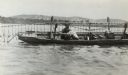
| Description: | A clam fisher in a boat on the Mississippi River near Prairie du Chien. Attached to the long rod are many small hooks similar to grappling hooks. As the bo... |

| Date: | |
|---|---|
| Description: | View from shoreline of the steamship "Cape Girardeau" in the Mississippi River near Cape Girardeau. Many passengers are on board the ship as it prepares to... |
| Date: | |
|---|---|
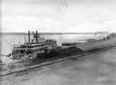
| Description: | Elevated view of the steamboat "Bald Eagle" unloading on the riverfront. "Bald Eagle" is painted on the top of the ship. Several men are working on and nea... |

| Date: | 1936 |
|---|---|
| Description: | This 1936 Wisconsin Conservation Dept. map shows the locations of state forestry Civilian Conservation Corps (CCC) camps, closed state forestry CCC camps, ... |

| Date: | 1937 |
|---|---|
| Description: | This Wisconsin Conservation Department map shows the locations of state forests, national forests, county forests, state nurseries, Indian reservations, st... |

| Date: | 1900 |
|---|---|
| Description: | View across water of men working to construct a brush dam about seven miles north of Cassville. There are two groups of well-dressed people, who appear to ... |

| Date: | |
|---|---|
| Description: | Elevated view from bluff overlooking the railroad tracks and yard along the Mississippi River. A group of men are gathered on the track near stacks of lumb... |

| Date: | 1936 |
|---|---|
| Description: | Four men are building the wall at Signal Point Lookout in Wyalusing State Park. They are part of Works Progress Administration (WPA) Project #8656-8. Th... |

| Date: | 1839 |
|---|---|
| Description: | This map, one of a series made by Thomas Jefferson Cram of the U.S. Topographical Engineers from personal surveys, covers the area from Green Bay to the ju... |
If you didn't find the material you searched for, our Library Reference Staff can help.
Call our reference desk at 608-264-6535 or email us at: