 Filter: Categories of Wisconsin Historical Images
Filter: Subject of Work
Filter: Subject of michigan, lake
Filter: Categories of Wisconsin Historical Images
Filter: Subject of Work
Filter: Subject of michigan, lake

| Date: | 1962 |
|---|---|
| Description: | Sailors passing cases of bottled Coca-Cola (soda) from an International truck to a ship docked at Chicago. City skyline in background. |
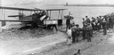
| Date: | 1929 |
|---|---|
| Description: | A Loening Amphibian, one of three such airplanes in which the Kohler Aviation Company provided passenger service from Milwaukee across Lake Michigan. |
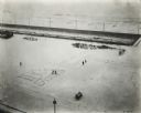
| Date: | 1921 |
|---|---|
| Description: | Elevated view of Grant Park and cars on the adjacent street taken from the International Harvester offices. |
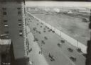
| Date: | 1920 |
|---|---|
| Description: | Elevated view from a window of the International Harvester offices on Michigan Avenue showing Grant Park. Company employees have written their department n... |

| Date: | 1936 |
|---|---|
| Description: | This 1936 Wisconsin Conservation Dept. map shows the locations of state forestry Civilian Conservation Corps (CCC) camps, closed state forestry CCC camps, ... |

| Date: | 1937 |
|---|---|
| Description: | This Wisconsin Conservation Department map shows the locations of state forests, national forests, county forests, state nurseries, Indian reservations, st... |
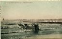
| Date: | 1908 |
|---|---|
| Description: | Group of men on a life saving crew launching a rowboat into Lake Michigan. A long pier with a lighthouse at the end bisects the horizon. Caption reads: "Li... |
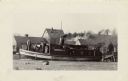
| Date: | 1931 |
|---|---|
| Description: | The Frank Braeger is moored on the shore of Jones Island with steam issuing from the pipe, with the crew posing on the boat. In the background a man... |

| Date: | 1839 |
|---|---|
| Description: | This map, one of a series made by Thomas Jefferson Cram of the U.S. Topographical Engineers from personal surveys, covers the area from Green Bay to the ju... |

| Date: | 07 1959 |
|---|---|
| Description: | Dickey Chapelle taking photographs on the beach in Milwaukee during Operation Inland Seas. A Navy ship is on Lake Michigan in the background on the left. A... |

| Date: | 1965 |
|---|---|
| Description: | This series of 17 maps show boundaries and changes in city limits from 1846 to 1965. The base of all of the maps are the same, Milwaukee and suburbs. All m... |
If you didn't find the material you searched for, our Library Reference Staff can help.
Call our reference desk at 608-264-6535 or email us at: