 Filter: Categories of Wisconsin Historical Images
Filter: Subject of Wisconsin River (Wis.)
Filter: County of Adams
Filter: Categories of Wisconsin Historical Images
Filter: Subject of Wisconsin River (Wis.)
Filter: County of Adams

| Date: | 1955 |
|---|---|
| Description: | Aerial view of Castle Rock Dam on the Wisconsin River. |
| Date: | |
|---|---|
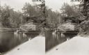
| Description: | Stereograph of the steamboat the "Dell Queen" at Chapel Gorge. A woman and a young child sit on the shoreline. |
| Date: | 1916 |
|---|---|
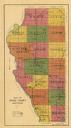
| Description: | This early 20th century map of Adams County, Wisconsin, shows the township and range grid, towns, sections, cities and villages, roads, railroads, lakes an... |
| Date: | 1900 |
|---|---|
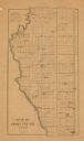
| Description: | This map of Adams County, Wisconsin, from E.B. Foote's Plat book of Adams County, Wisconsin, 1900, shows the township and range grid, towns, sections, citi... |

| Date: | 1930 |
|---|---|
| Description: | View across lawn of long grass towards a log cabin next to the Wisconsin River. An automobile is parked on the left near the porch. |

| Date: | 01 01 1856 |
|---|---|
| Description: | This map is mounted on cloth and shows lots, as well as location of the public square and college. Streets are labeled as is the Wisconsin River. |
| Date: | 07 09 1911 |
|---|---|
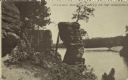
| Description: | Text on front reads: "Chimney Rock, Dells of the Wisconsin." The rock formation Chimney Rock overhanging the Wisconsin River. Bluffs are on the left and th... |
If you didn't find the material you searched for, our Library Reference Staff can help.
Call our reference desk at 608-264-6535 or email us at: