 Filter: Categories of Wisconsin Historical Images
Filter: Subject of Weapons
Filter: Year of 1700-1799
Filter: Categories of Wisconsin Historical Images
Filter: Subject of Weapons
Filter: Year of 1700-1799

| Date: | 1740 |
|---|---|
| Description: | Engraved and hand-colored map of the Iberian peninsula as a theater of war during the War of the Spanish Succession (1701-1714). The map is dedicated to Ki... |

| Date: | 1746 |
|---|---|
| Description: | A map of the western hemisphere, including parts of western Europe and Africa, showing the division of the Americas by the European powers. Weapons and fol... |

| Date: | 1755 |
|---|---|
| Description: | This map shows the eastern half of North America during the French and Indian war, including cities, borders, Native American Land, forts, and detailed geo... |

| Date: | 1790 |
|---|---|
| Description: | An updated and corrected version of Robert de Vaugondy's 1750 map "Amérique Septentrionale: Dressée sur les Relations les Plus Modernes des Voyageurs et Na... |
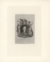
| Date: | 1774 |
|---|---|
| Description: | Engraved portrait of Samuel Adams, a Founding Father of the United States and 4th Governor of Massachusetts (1792-1794). Adams' portrait is framed in an ov... |
If you didn't find the material you searched for, our Library Reference Staff can help.
Call our reference desk at 608-264-6535 or email us at: