 Filter: Categories of Wisconsin Historical Images
Filter: Subject of Warships
Filter: Categories of Wisconsin Historical Images
Filter: Subject of Warships
| Date: | 01 12 1944 |
|---|---|
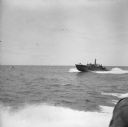
| Description: | View of two PT (Patrol Torpedo) boats from another PT boat, off of the north coast of New Guinea (present day Papua New Guinea). PT (Patrol Torpedo) boats ... |
| Date: | 01 12 1944 |
|---|---|
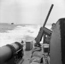
| Description: | View of a PT (Patrol Torpedo) boat from another PT boat, off of the north coast of New Guinea (present day Papua New Guinea). PT (Patrol Torpedo) boats wer... |
| Date: | 01 21 1944 |
|---|---|
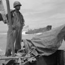
| Description: | Corporal Andrew Starkie of Chicago, Illinois, stands next to the flagpole on a LCV (Landing Craft, Vehicle) off of the coast of Saidor, New Guinea (present... |

| Date: | 02 05 1944 |
|---|---|
| Description: | General view of Port Moresby Harbor from road, New Guinea (present day Papua New Guinea). A jeep is on the road on the left. Several soldiers are near a sh... |
| Date: | 1945 |
|---|---|
| Description: | Robert Doyle, Journal war correspondent, took his wire recorder aboard the battleship Wisconsin while it was part of Admiral Halsey's 3rd fleet off ... |

| Date: | 1944 |
|---|---|
| Description: | A smiling Robert Doyle is transferred between two ships using a manila highline in a transfer-at-sea chair, also called a boatswain's chair. He is wearing ... |
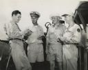
| Date: | 07 29 1945 |
|---|---|
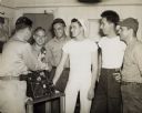
| Description: | Robert Doyle poses with two other journalists and a ship's captain on the deck while aboard an escort carrier near Japan. Identified (left to right) are Al... |
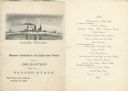
| Date: | 11 26 1898 |
|---|---|
| Description: | Menu for a "Banquet tendered by the Union Iron Works to the Delegation from the Badger State" given at the Palace Hotel, with an etching of the Battleship ... |
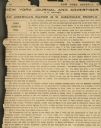
| Date: | 02 17 1898 |
|---|---|
| Description: | An editorial article in the "New York Journal" written by William Randolph Hearst in the wake of the sinking of the "Maine." |

| Date: | 1919 |
|---|---|
| Description: | German U-boat commander Lieutenant Brandt (played by Wallace Beery) and American Merchant Marine Captain Oscar Krug (Hobart Bosworth) face a crowd of angry... |

| Date: | 1919 |
|---|---|
| Description: | In a scene still for the silent drama "Behind the Door," American Merchant Marine Captain Oscar Krug (played by Hobart Bosworth) has been left to drown on ... |

| Date: | 1740 |
|---|---|
| Description: | Engraved and hand-colored map of the Iberian peninsula as a theater of war during the War of the Spanish Succession (1701-1714). The map is dedicated to Ki... |
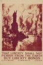
| Date: | 1918 |
|---|---|
| Description: | United States government bonds poster in the Fourth Liberty Loan "B" series. "Buy Liberty Bonds. Fourth Liberty Loan." Depicts enemy aircraft bombing New Y... |

| Date: | 03 1945 |
|---|---|
| Description: | Crew of the U.S.S. Franklin watching a vaudeville performance from their hangar deck. The performance took place just seven days after the ship was ... |

| Date: | 03 1945 |
|---|---|
| Description: | Elevated view looking down towards a group of men taking a wounded soldier down a ramp from the USS Samaritan to a waiting ambulance. Several milita... |

| Date: | 07 1959 |
|---|---|
| Description: | Dickey Chapelle taking photographs on the beach in Milwaukee during Operation Inland Seas. A Navy ship is on Lake Michigan in the background on the left. A... |

| Date: | 10 1776 |
|---|---|
| Description: | Broadside map showing the British invasion of New York city in August and September of 1776. The map shows important cities, forts, roads, hills, mountains... |

| Date: | 02 1777 |
|---|---|
| Description: | Map depicting the campaigns of October and November 1776, in Manhattan, Westchester, and part of New Jersey, published only a few months after the conclusi... |

| Date: | 03 1777 |
|---|---|
| Description: | Map showing the British and Hessian attack on Fort Washington in November of 1776. The movements and fortifications of the British and Hessian troops appea... |
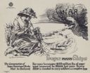
| Date: | 1917 |
|---|---|
| Description: | Poster with an illustration of a woman drinking out of a glass with a straw, while below her miniaturized ships labeled "ARMS," "FOOD," "SOLDIERS" and "SU... |
If you didn't find the material you searched for, our Library Reference Staff can help.
Call our reference desk at 608-264-6535 or email us at: