 Filter: Categories of Wisconsin Historical Images
Filter: Subject of Voyages and travels
Filter: Categories of Wisconsin Historical Images
Filter: Subject of Voyages and travels
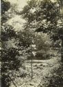
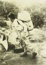
| Date: | 1909 |
|---|---|
| Description: | A view through foliage of the canoes at the Presque Isle River, where The Gang completed their first portage of the trip. |
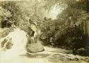
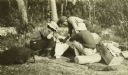
| Date: | 1909 |
|---|---|
| Description: | Two of The Gang carrying a canoe on a portage in the Presque Isle River. |

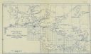
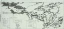
| Date: | 1909 |
|---|---|
| Description: | A hand-drawn and illustrated map of The Gang's trip from their seventh camp to Lake Superior. |
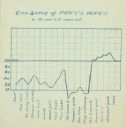
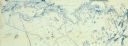
| Date: | 1909 |
|---|---|
| Description: | A hand-drawn cyanotype chart tracking Piffy's (Charles Isley's) morale. |
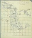
| Date: | |
|---|---|
| Description: | A geological map of the Rainy Lake region in Minnesota and Ontario. |
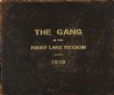
| Date: | 1910 |
|---|---|
| Description: | The brown leather cover of the journal of Howard Greene's Rainy Lake canoe trip. The title "The Gang in the Rainy Lake Region, 1910" is stamped onto the le... |
| Date: | 1910 |
|---|---|
| Description: | Carl Greene's drawing of a map of The Gang's trip to Winton, titled "We drive to Winton." This map shows a road currently known as the Thirteen Corners Roa... |
| Date: | 1910 |
|---|---|
| Description: | The Gang standing on Fisherman's Dock on Fall Lake with their travel supplies at the beginning of their trip. Billy Mac is second from the left, and third ... |
| Date: | 1910 |
|---|---|
| Description: | Notes written by ranger J.B. MacDonald regarding routes for The Gang to follow. |
| Date: | 1910 |
|---|---|
| Description: | The Gang is sitting on their packs or bedrolls as they consult their maps with a ranger. |
| Date: | 1910 |
|---|---|
| Description: | Carl carrying a large pack on his back and holding a bag. He is wearing a beaded belt that was almost certainly made by an Indian. |
| Date: | |
|---|---|
| Description: | A detailed blueprint map showing the route of Howard Greene and The Gang's canoe trip through the Rainy Lake region in 1910. |
| Date: | 1911 |
|---|---|
| Description: | A map of St. Louis County, Minnesota that traces the route of Howard Green and The Gang's canoe trip from Tower to Ranier. |
| Date: | |
|---|---|
| Description: | A blueprint map with an overlay traced in pencil of the routes of Howard Greene and The Gang's 1910 and 1911 canoe trips. |
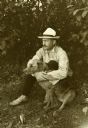
| Date: | 1907 |
|---|---|
| Description: | Bill Marr sitting on the ground outdoors with his arms around Carl's Airedale dog, Diadem (Di). |
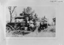
| Date: | 02 16 1928 |
|---|---|
| Description: | A group of people are with a truck, probably in Africa. |
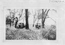
| Date: | 02 16 1928 |
|---|---|
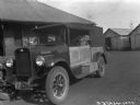
| Description: | View of two trucks parked among trees and tall grass, probably in Africa. |
| Date: | 12 1927 |
|---|---|
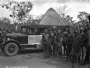
| Description: | "Sahara" trucks in a village in Africa. A man is sitting in the driver's seat of the truck. Villagers, including children, are standing together near the t... |
| Date: | 12 1927 |
|---|---|
| Description: | Three-quarter view from front left of a "Sahara" truck parked in a village in Africa. There is a large building in the background, and two smaller building... |
| Date: | 12 1927 |
|---|---|
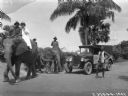
| Description: | "Sahara" truck preceded by men riding two elephants near coconut trees in a village in the Sahara desert. In the background is the roof of a large, perhaps... |
If you didn't find the material you searched for, our Library Reference Staff can help.
Call our reference desk at 608-264-6535 or email us at: