Filter: Categories of Wisconsin Historical Images
Filter: Subject of Valleys
Filter: Year of 1900-1999
Filter: Categories of Wisconsin Historical Images
Filter: Subject of Valleys
Filter: Year of 1900-1999

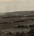
| Date: | 1958 |
|---|---|
| Description: | Aerial view of contour strip farming with the Obert Olstad farm in foreground. The Carl Backum farm is in the background. |
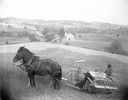
| Date: | 1900 |
|---|---|
| Description: | Slightly elevated view of a farmer harvesting grain on a hill or ridge with a horse-drawn McCormick grain binder near Pittsburgh. In the background is a va... |
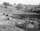
| Date: | 05 16 1962 |
|---|---|
| Description: | Wrecked and abandoned automobiles in a hidden rural hollow. |
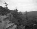
| Date: | 07 29 1928 |
|---|---|
| Description: | Elevated view of Devil's Lake State Park from East Bluff, looking east toward the valley. |
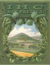
| Date: | 1914 |
|---|---|
| Description: | Front cover of an advertising catalog for IHC hay presses featuring an illustration of a landscape of a valley with farms and fields. |
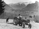
| Date: | 1960 |
|---|---|
| Description: | German farmers pulling a wooden log with a McCormick D-435 tractor against a mountainous backdrop in Alpine country. |
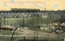
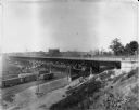
| Date: | 1911 |
|---|---|
| Description: | Elevated view across valley toward a streetcar viaduct on the Waukesha Interurban Line, near Milwaukee. Caption reads: "Street Car Bridge on Waukesha Inter... |

| Date: | 05 10 1928 |
|---|---|
| Description: | The Lutheran Church and buildings, seen from Lutheran Church Hill. |

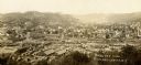
| Date: | 1905 |
|---|---|
| Description: | Elevated view from hill towards Elmwood. Tree-covered bluffs are in the distance. Caption reads: "Bird's Eye View of Elmwood, Wis." |
| Date: | 1922 |
|---|---|
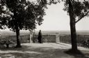
| Description: | View of a man standing at a fence and looking out over the land below Holy Hill. |

| Date: | 1955 |
|---|---|
| Description: | Elevated view from Holy Hill of the valley below. The roof and side of the church is on the left. |
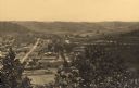
| Date: | 1900 |
|---|---|
| Description: | Elevated view of town from hill. Caption reads: "Birds Eye View Richland Center, Wis". |

| Date: | 11 1951 |
|---|---|
| Description: | Aerial view of US Highway 14 southeast of La Crosse descending into Mormon Coulee. The original caption of the print, which is undated, describes the road ... |
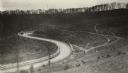
| Date: | 1920 |
|---|---|
| Description: | Loganville Road in Sauk County taken by the Wisconsin Good Roads Association. The photograph was meant to create a contrast between the new improved road ... |
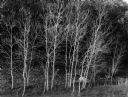
| Date: | 10 23 1960 |
|---|---|
| Description: | Stand of small bare aspen trees, Trout Creek Valley. |
| Date: | 09 01 1910 |
|---|---|
| Description: | 27th Street viaduct looking north, Menomonee Valley area, with gas holders of the Milwaukee Gas Light Co. in the background. Pedestrians and wagons are cro... |

| Date: | 08 27 1910 |
|---|---|
| Description: | Looking south towards the 16th Street viaduct over Menominee Valley from about Clybourn Street. Shows the surrounding industrial area and neighborhoods. Se... |

| Date: | 1911 |
|---|---|
| Description: | Looking north at the Menomonee Valley. Road incorrectly identified on the postcard as twenty-second street viaduct. Pedestrians and carriages are crossing ... |
If you didn't find the material you searched for, our Library Reference Staff can help.
Call our reference desk at 608-264-6535 or email us at: