 Filter: Categories of Wisconsin Historical Images
Filter: Subject of Valleys
Filter: Categories of Wisconsin Historical Images
Filter: Subject of Valleys

| Date: | 1940 |
|---|---|
| Description: | This map of southeastern Wisconsin depicts the Rock and Milwaukee rivers and the Kettle Moraine area. Cities and villages are identified. Stamp stating "Po... |
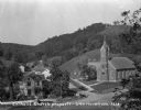
| Date: | 1925 |
|---|---|
| Description: | Elevated view of the Catholic church, residential homes, with hills and trees in the background. |
| Date: | 08 1983 |
|---|---|
| Description: | "The camera, with a long lens, looks across the valley." |
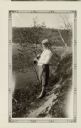
| Date: | 1920 |
|---|---|
| Description: | A well-dressed man identified as Uncle Rudolph Schenck takes in the view from a bluff overlooking the Fish Creek valley and harbor. There are houses and ou... |
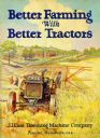
| Date: | 1925 |
|---|---|
| Description: | Front cover of a booklet advertising the J.I. Case Threshing Machine Company's line of tractors. The cover features a color illustration of a farmer using ... |

| Date: | 1892 |
|---|---|
| Description: | This map shows the dams and locks of the Fox River between Neenah, in Winnebago County, Wisconsin, and Kaukauna, in Outagamie County. The cities and villag... |

| Date: | 1890 |
|---|---|
| Description: | Shows vacant state land, government land, townships, and selected farms, camps, saw mills, etc. in Vilas and Oneida Counties, and part of Iron County. "For... |
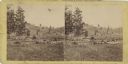
| Date: | 1863 |
|---|---|
| Description: | Stereograph of a scene near the site of the Gettysburg battlefield. Two men sit in a wagon in the center of the image. |

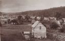
| Date: | |
|---|---|
| Description: | View from a hill towards houses and outbuildings. A man stands on a board sidewalk in front of a group of houses. A woman and young girl stand near the ent... |
| Date: | |
|---|---|
| Description: | View across dirt road of farms and farm buildings in a valley. |

| Date: | |
|---|---|
| Description: | A view of Coon Valley at sunrise, including a wooden building, a fence, and trees. |

| Date: | |
|---|---|
| Description: | View from above of Elephant's Foot Rock with Woodstock in the valley below. |
| Date: | 1928 |
|---|---|
| Description: | View down valley of a procession of hundreds of pilgrims walking up the hill to St. Anne's Chapel which is lined with Stations of the Cross. The crowd is w... |
| Date: | |
|---|---|
| Description: | The earth is never still, but speaks her lovers lying twined among the roots of grasses, lying long stretched out from hill to hill There wher... |
| Date: | 1935 |
|---|---|
| Description: | Selma Eidsmoe, wearing knickers and a head scarf, poses holding a gun over her shoulder. She is standing on a bluff above the Pecatonica River valley. She ... |
| Date: | 1893 |
|---|---|
| Description: | Valley view of town buildings and hillside. |

| Date: | 09 10 1961 |
|---|---|
| Description: | Kickapoo Valley landscape with a dead white tree in the vicinity of Highway 131. |

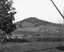
| Date: | 1960 |
|---|---|
| Description: | Large pasture valley between Black Earth and Marxville, at sunset. |

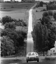
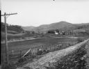
| Date: | 07 04 1960 |
|---|---|
| Description: | Elevated view from Highway P on a hill looking down across valley pastureland, between Black Earth and Marxville. |
| Date: | 1885 |
|---|---|
| Description: | Timber railroad trestle over a wooded valley, apparently at the final stage of construction. |
If you didn't find the material you searched for, our Library Reference Staff can help.
Call our reference desk at 608-264-6535 or email us at: