 Filter: Categories of Wisconsin Historical Images
Filter: Subject of Valleys
Filter: County of La Crosse
Filter: Categories of Wisconsin Historical Images
Filter: Subject of Valleys
Filter: County of La Crosse
| Date: | |
|---|---|
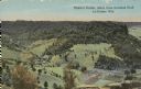
| Description: | Colorized view of Ebner's Coulee. Caption reads: "Ebner's Coulee, taken from Grandad Bluff, La Crosse, Wis." |

| Date: | 11 1951 |
|---|---|
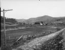
| Description: | Aerial view of US Highway 14 southeast of La Crosse descending into Mormon Coulee. The original caption of the print, which is undated, describes the road ... |
| Date: | |
|---|---|
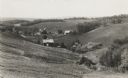
| Description: | View across dirt road of farms and farm buildings in a valley. |
| Date: | 1936 |
|---|---|
| Description: | View down hill towards valley of farming country in the “Coulee Region.” |

| Date: | 10 1891 |
|---|---|
| Description: | This blueprint map shows land ownership and buildings. Text below the title reads: "The La Crosse Heights include the ridge of land with the spurs projecti... |
| Date: | |
|---|---|
| Description: | View from a hay field on a hill looking towards pastures and fields in a valley. Caption reads: "Harvest Scene in Bostwick Valley, La Crosse, Wis." |
| Date: | |
|---|---|
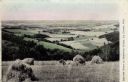
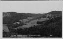
| Description: | Photographic postcard view of a coulee landscape. Agricultural fields are on a hillside. Caption reads: "Coulee Scene near La Crosse, Wis." |
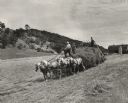
| Date: | 1952 |
|---|---|
| Description: | A woman is driving a horse-drawn hay wagon pulling a hay loader on the William Houser Farm. A child and a man, each with a hay fork, are riding on the load... |
If you didn't find the material you searched for, our Library Reference Staff can help.
Call our reference desk at 608-264-6535 or email us at:
