 Filter: Categories of Wisconsin Historical Images
Filter: Subject of Trails
Filter: Categories of Wisconsin Historical Images
Filter: Subject of Trails
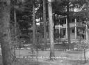
| Date: | 1931 |
|---|---|
| Description: | View across stone-lined paths toward the annex, a three-story building with a porch and a balcony above. Pines trees are on the grounds, and there is a sma... |
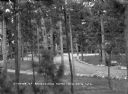
| Date: | 1931 |
|---|---|
| Description: | Elevated view of the pines on the grounds of Ravenswood. Benches are set along a stone-lined path and an automobile is parked behind the trees on the right... |
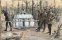
| Date: | |
|---|---|
| Description: | An illustration created using cutout photographs and white, gray and black paint on cream colored paper. The scene depicts, in profile, a man pulling a loa... |

| Date: | |
|---|---|
| Description: | Girl pos700011270039 standing next to a stump next to a small baby stroller with a doll in it, on the side of a dirt road or path. Behind the girl are bush... |
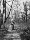
| Date: | 1905 |
|---|---|
| Description: | Mary E. Smith walking down a sunlit path through trees. She is carrying a bouquet of freshly picked flowers. |

| Date: | 1905 |
|---|---|
| Description: | Dr. Joseph Smith strolling down a path with his hand in his left pocket. |
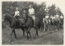
| Date: | |
|---|---|
| Description: | Group of campers and a camp counselor riding on horseback on a trail in wooded area. Original caption notes: "Riding is one of the most popular sports. Eng... |

| Date: | 1906 |
|---|---|
| Description: | Mary E. Smith walking along a path in a park in Vienna, Austria holding an umbrella. |

| Date: | 1900 |
|---|---|
| Description: | View from path of a footbridge over the lagoon in Tenney Park. A man is walking along the path on the right. Trees are along the shoreline. |
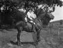
| Date: | 1908 |
|---|---|
| Description: | Flora Fels Weege sitting on top of a horse holding a rifle. She is wearing a men's suit, a hat, and a belt holding ammunition. |

| Date: | 1800 |
|---|---|
| Description: | This map shows the land claim owned by the Portage Canal Company and includes an index of landownership and landmarks. The Wisconsin and Portage River, the... |

| Date: | 1800 |
|---|---|
| Description: | This map is pencil on tracing paper and shows marshes, the Wisconsin River, Indian trails, and Indian boundary line. The upper left corner reads: "Let sect... |

| Date: | |
|---|---|
| Description: | View down wooden foot bridge towards a woman standing with her arm resting on the railing. She is holding a bunch of flowers in her right hand. In the back... |

| Date: | |
|---|---|
| Description: | View down wooden foot bridge towards a woman standing and leaning on a the railing. There is a pathway in the background leading to the bridge. |

| Date: | 1941 |
|---|---|
| Description: | This map is ink and watercolor on cardboard and shows Native American legends and villages pictorially. Trails are also shown. |

| Date: | 03 20 1986 |
|---|---|
| Description: | View of Quarry Drive, a sunken path lined with trees, near Mendota Heights. Branches and stones obstruct the pathway. |

| Date: | |
|---|---|
| Description: | View down tree-lined path on the University of Wisconsin grounds. |

| Date: | 1836 |
|---|---|
| Description: | This map was created to accompany a congressional report shows the then Wisconsin Territory, including present-day states of Wisconsin, Minnesota, Iowa, an... |

| Date: | 1941 |
|---|---|
| Description: | This is map one of three maps that show trails, roads and fire lanes, utilities, resorts, submerged lakes, vegetation, flowage right lands, and timber righ... |

| Date: | 02 1937 |
|---|---|
| Description: | This topographical map of the forest preserve shows highways, roads, trails, telephone lines, Native American reservations, Ranger sub-stations, state nurs... |
If you didn't find the material you searched for, our Library Reference Staff can help.
Call our reference desk at 608-264-6535 or email us at: