 Filter: Categories of Wisconsin Historical Images
Filter: Subject of Trails
Filter: County of Sauk
Filter: Categories of Wisconsin Historical Images
Filter: Subject of Trails
Filter: County of Sauk
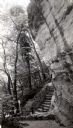
| Date: | 1945 |
|---|---|
| Description: | Tower Hill State Park trail leading to the top of the shot tower shaft. |
| Date: | 1945 |
|---|---|
| Description: | Tower Hill State Park trail to the top of the shot tower shaft. |
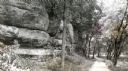
| Date: | 1963 |
|---|---|
| Description: | A trail leading into Parfrey's Glen in Devil's Lake State Park. Parfrey's Glen was Wisconsin's first State Natural Area in 1952. |

| Date: | 1935 |
|---|---|
| Description: | A man stands at the end of a country lane lined with trees and carpeted with leaves. The trees overhead form a Gothic arch. The top of a wooden fence and g... |
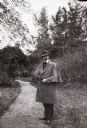
| Date: | 1930 |
|---|---|
| Description: | The photographer stands on a park or garden path holding his gloves. He wears a coat with attached cape, hat, and large cravat. |

| Date: | |
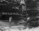
|---|---|
| Description: | Entrance to Cold Water Canyon near Wisconsin Dells. In the foreground is a wooden walkway across the water. |
| Date: | 1929 |
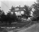
|---|---|
| Description: | A pathway through tall grass, beaten by tire tracks, leading to the side porch of the community house. |
| Date: | 1925 |
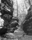
|---|---|
| Description: | Rock formations at Congress Hall on the Dell View Resort property. |
| Date: | 1925 |
|---|---|
| Description: | A man and woman pose at the wooden walkway among the rock formations of Congress Hall, on the Dell View Resort property. |
| Date: | 1925 |
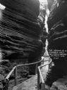
|---|---|
| Description: | View down a narrow wooden walkway through rock formations at Congress Hall, on the Dell View Resort property. |

| Date: | 1921 |
|---|---|
| Description: | A high wooden pedestrian bridge along a forest path, crossing over a deep gorge. |

| Date: | 1908 |
|---|---|
| Description: | Ruth and Miriam Bennett on a wooden walkway at Mirror Lake. |

| Date: | 1920 |
|---|---|
| Description: | This map of Devil's Lake State Park in Sauk County, Wisconsin, shows the park limits, railroads, roads, creeks, trails, and points of interest in the area.... |

| Date: | 1926 |
|---|---|
| Description: | Map showing Devil's Lake State Park limits, railroads, roads, creeks, trails, and park sites. Accompanying text about the location, natural features, attra... |

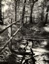
| Date: | |
|---|---|
| Description: | View down trail along steep hill in the woods with birch and pine trees. A sign posted on a tree reads: "To The Cave." |
| Date: | |
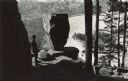
|---|---|
| Description: | Elevated view of a man standing on a rock looking over a frozen Devil's Lake in front of a Balanced Rock. Original caption: "There are some startling rock ... |

| Date: | 1949 |
|---|---|
| Description: | This map shows points of interest, historic sites, buildings, trails, roads, and general animal and plant locations. |
If you didn't find the material you searched for, our Library Reference Staff can help.
Call our reference desk at 608-264-6535 or email us at: