 Filter: Categories of Wisconsin Historical Images
Filter: Subject of Surveying
Filter: Categories of Wisconsin Historical Images
Filter: Subject of Surveying
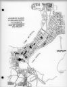
| Date: | 03 16 1950 |
|---|---|
| Description: | Map of locations by block of dwellings rated as blighted as part of the Madison Housing Authority Survey of Substandard Housing. |
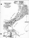
| Date: | 03 16 1950 |
|---|---|
| Description: | Map of locations of blocks of dwellings rated as slums, as part of the Madison Housing Authority Survey of Substandard Housing. |
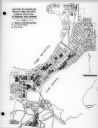
| Date: | 03 16 1950 |
|---|---|
| Description: | Map of locations by blocks or areas of dwelling units in which violations of ordinance were apparent as part of the Madison Housing Authority Survey of Sub... |

| Date: | 03 16 1950 |
|---|---|
| Description: | A chart showing distribution of 1,148 substandard dwelling units found in the survey area, by basic type of fault, as part of the Madison Housing Authority... |
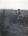
| Date: | 1920 |
|---|---|
| Description: | A.L. Webster takes notes in a notebook while using tools to do surveying work in a field. Another man stands holding a rod in the background near what appe... |

| Date: | 1835 |
|---|---|
| Description: | This map of Wisconsin Territory was compiled by public surveys in 1835; it is limited to modern-day southern Wisconsin. Included are two insets – one of th... |

| Date: | 1839 |
|---|---|
| Description: | This map shows the portion of Wisconsin south and east of the Wisconsin and Fox rivers. Roads, forts, cities both existing and "planned" and counties are i... |
| Date: | 1970 |
|---|---|
| Description: | "Surveying Crew on McArthur Rd. Sunny Brae farm is in background." |

| Date: | 1920 |
|---|---|
| Description: | This map identifies the areas of the state that had been geologically surveyed or topographically surveyed, or both, as well as portions of the state still... |

| Date: | 1956 |
|---|---|
| Description: | A map depicting the for systems of land description in Wisconsin, which include metes and bounds, U.S. System of Rectangular Surveys, Latitude and longitud... |

| Date: | 1846 |
|---|---|
| Description: | A map of Wisconsin and a portion of Minnesota that show the township surveys in progress in portions of the Saint Croix River region and in central Wiscons... |

| Date: | 1848 |
|---|---|
| Description: | Map of Wisconsin and a portion of Minnesota showing the township surveys in progress in portions of the Saint Croix River region and in central Wisconsin a... |

| Date: | 10 21 1855 |
|---|---|
| Description: | Map of the Wisconsin and the Minnesota Territory showing the status of township surveys in Wisconsin and southeastern Minnesota. The Wisconsin reservation... |
| Date: | |
|---|---|
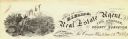
| Description: | Letterhead of H.I. Bliss, a real estate agent, civil engineer, and county surveyor in La Crosse, Wisconsin. On the left a group of three men are surveying ... |

| Date: | |
|---|---|
| Description: | Field notes taken for T6N R17E between 6 and 7 on the original township survey of Wisconsin. |

| Date: | 1867 |
|---|---|
| Description: | This map of the battlefield on the North Anna River at Hanover Junction illustrates the Union positions in blue and Confederate positions in red. Roads, ra... |

| Date: | 1860 |
|---|---|
| Description: | A survey map of Wisconsin, southeastern Minnesota, and northern Iowa, showing the status of surveys, rivers, and lakes. The map also shows the locations of... |

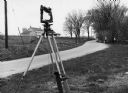
| Date: | 03 09 1955 |
|---|---|
| Description: | A man wearing a hat looks through the eye piece of his surveying instrument, called a 'theodolite,' which rests on a tripod. |

| Date: | 1875 |
|---|---|
| Description: | Map of the triangulations made from Vulcan on the Keweenaw Peninsula in the Upper Peninsula of Michigan south through eastern Wisconsin, past Chicago to Ba... |

| Date: | 1877 |
|---|---|
| Description: | A map of the triangulation and reconnaissance along the southwest corner of Wisconsin. The map shows the river systems, railroads, cities, and villages tha... |
If you didn't find the material you searched for, our Library Reference Staff can help.
Call our reference desk at 608-264-6535 or email us at: