 Filter: Categories of Wisconsin Historical Images
Filter: Subject of Surveying
Filter: Community of Madison
Filter: Categories of Wisconsin Historical Images
Filter: Subject of Surveying
Filter: Community of Madison
| Date: | 03 16 1950 |
|---|---|
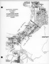
| Description: | Map of areas surveyed by block number as part of the Madison Housing Authority Survey of Substandard Housing. |
| Date: | 03 16 1950 |
|---|---|
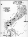
| Description: | Map of locations by block of dwellings rated as blighted as part of the Madison Housing Authority Survey of Substandard Housing. |
| Date: | 03 16 1950 |
|---|---|
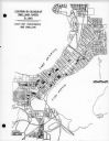
| Description: | Map of locations of blocks of dwellings rated as slums, as part of the Madison Housing Authority Survey of Substandard Housing. |
| Date: | 03 16 1950 |
|---|---|
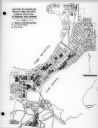
| Description: | Map of locations by blocks or areas of dwelling units in which violations of ordinance were apparent as part of the Madison Housing Authority Survey of Sub... |

| Date: | 03 16 1950 |
|---|---|
| Description: | A chart showing distribution of 1,148 substandard dwelling units found in the survey area, by basic type of fault, as part of the Madison Housing Authority... |

| Date: | 03 09 1955 |
|---|---|
| Description: | A man wearing a hat looks through the eye piece of his surveying instrument, called a 'theodolite,' which rests on a tripod. |

| Date: | 07 14 1958 |
|---|---|
| Description: | This is a Tellurometer, a microwave surveying instrument. The operator is Don Reed, field man for Alster and Associates, Washington, D.C., which completed ... |

| Date: | 1873 |
|---|---|
| Description: | This map shows lots and blocks, additions and subdivisions, and large-scale landownership. The map is oriented with north to the upper right. The map is fr... |

| Date: | 02 02 1960 |
|---|---|
| Description: | The Madison Redevelopment Authority joined in the city's program of locating and permanently marking land survey corners in the Madison area. Here they mar... |

| Date: | 1900 |
|---|---|
| Description: | A class of engineering students practicing surveying in front of Science Hall, located on the University of Wisconsin (Madison) campus. Eleven engineering ... |

| Date: | 1982 |
|---|---|
| Description: | A segment of the trunk of a pine bears the scars of a "blaze" carved with an ax and bearing the inscription: "XIX T. J. Cram, D. Houghton Aug 11, 1841." C... |
If you didn't find the material you searched for, our Library Reference Staff can help.
Call our reference desk at 608-264-6535 or email us at: