 Filter: Categories of Wisconsin Historical Images
Filter: Subject of Superior, Lake
Filter: Categories of Wisconsin Historical Images
Filter: Subject of Superior, Lake

| Date: | 1857 |
|---|---|
| Description: | A color-coded map of the Lake Superior region, including portions of Wisconsin, Minnesota and Michigan. |

| Date: | 1863 |
|---|---|
| Description: | Map of the west end of Lake Superior, including Superior, St. Louis, and Allouez Bays. |
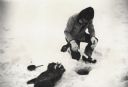
| Date: | |
|---|---|
| Description: | Man ice fishing on Chequamegon Bay through a hole with a fishing jig, fish and fry pan. |
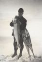
| Date: | |
|---|---|
| Description: | Fisherman standing on frozen Lake Superior holding a lake trout, leaning on snowshoes. |
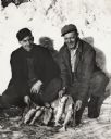
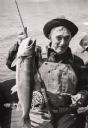
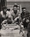
| Date: | 1950 |
|---|---|
| Description: | Vern Frechette (left) and Leonard Larson show their catch of trout caught during ice fishing on Chequamegon Bay. |
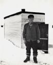
| Date: | |
|---|---|
| Description: | Ice fisherman Bruno Grotzke of Ashland poses in front of his fishing shanty on Chequamegon Bay. |
| Date: | |
|---|---|
| Description: | A fisherman sitting in a boat is holding a cigar and posing with lake trout. |
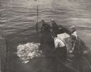
| Date: | 1955 |
|---|---|
| Description: | Three fisherman in a boat pulling in a net full of fish on Chequamegon Bay while a man and a boy look on. |
| Date: | 1838 |
|---|---|
| Description: | Map of the entire territories of Iowa and Wisconsin. |
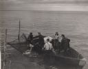
| Date: | 1955 |
|---|---|
| Description: | Four men and a boy netting trout from boat on Chequamegon Bay. |
| Date: | 1955 |
|---|---|
| Description: | Catch of lake trout displayed by three fisherman on the pier at Little Sand Bay. From left to right are Martin Johnson, Hermy Johnson, and Myron Lohman. |
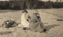
| Date: | 1920 |
|---|---|
| Description: | Mrs. Cora Hull & Mrs. Julia Wood are seated on the sandy shore of one of the Apostle Islands overlooking Lake Superior. |
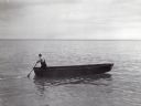
| Date: | |
|---|---|
| Description: | Lone man boating or fishing alone on Lake Superior. He is standing at the rear of the boat holding an oar. |

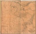
| Date: | 1890 |
|---|---|
| Description: | This map shows lakes, railroads, and rivers. An explanation of railroad lines with mileage in Wisconsin and total mileage for 1890 is included. Portions of... |
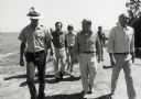
| Date: | 1979 |
|---|---|
| Description: | Senator Gaylord Nelson, Dave Obey, and Secretary of the Interior Cecil Andrus, walk along a beach with a park ranger during a tour of the Apostle Islands. ... |
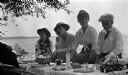
| Date: | 1914 |
|---|---|
| Description: | Four individuals, sitting in the shade near a table during a picnic on Madeline Island. Includes Elizabeth Nesbet (Mrs. S.C. Marty, Sr.), Gertrude Capser (... |
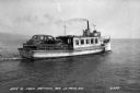
| Date: | 1938 |
|---|---|
| Description: | A car ferry transporting a car on Lake Superior between LaPointe, Madeline Island, and Bayfield. Two men are sitting on a bench near the car, and a shoreli... |
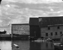
| Date: | 1969 |
|---|---|
| Description: | View from water of the sides of three wharf buildings in a bay of Lake Superior. |

| Date: | 1820 |
|---|---|
| Description: | Map of the Northwestern Territories of the United State showing the track pursued by the Expedition in 1820. |
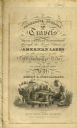
| Date: | 1820 |
|---|---|
| Description: | Narrative Journal of Travels from Detroit Northwest through the Great chain of American Lakes to the sources of the Mississippi River in the year 1820. Ill... |
If you didn't find the material you searched for, our Library Reference Staff can help.
Call our reference desk at 608-264-6535 or email us at: