 Filter: Categories of Wisconsin Historical Images
Filter: Subject of Suburbs
Filter: Creator Name of Vinje, Arthur M., 1888-1972
Filter: Categories of Wisconsin Historical Images
Filter: Subject of Suburbs
Filter: Creator Name of Vinje, Arthur M., 1888-1972
| Date: | 10 08 1945 |
|---|---|
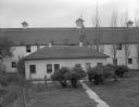
| Description: | A large barn and outbuilding on the Quaker Oats farm, 4202 Monona Drive. |
| Date: | 10 10 1945 |
|---|---|
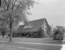
| Description: | Erwin and Claire Tiffany home, 1001 Seminole Highway, Nakoma. It was built in 1925, and was owned by Christina and Ellis Dana in 1945. |
| Date: | 09 30 1947 |
|---|---|
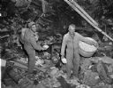
| Description: | James Capacio and John H. Endres, assistant to L.B. Kelly of the Solvit Chemical Company, distributing poison bread at the Shorewood dump in a rat extermin... |
| Date: | 09 30 1947 |
|---|---|
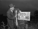
| Description: | James L. Clarke, city health inspector, placing a warning sign on a fence at the Shorewood dump after workers distributed poison bread bait in the dump. |
| Date: | 04 21 1948 |
|---|---|
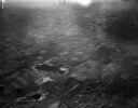
| Description: | Aerial photograph of the west side of Madison and the western edge of Lake Mendota. Taken over the west side of Madison looking northwest toward Middleton. |
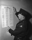
| Date: | 12 13 1948 |
|---|---|
| Description: | The street directory for Maple Bluff was delivered by Marshall A.J. Taft around the Christmas season. The contents of the directory reveal the growth of Ma... |
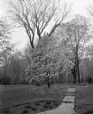
| Date: | 05 04 1949 |
|---|---|
| Description: | A stone pathway leads past a magnolia tree in full bloom along Butternut Road. |

| Date: | 02 14 1950 |
|---|---|
| Description: | Marshall high school gained basketball title honors in the Madison Suburban League for the sixth time in the 24-year history of the circuit. Coach Leonard ... |
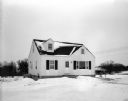
| Date: | 02 22 1950 |
|---|---|
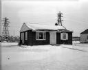
| Description: | Advertising photograph for a home in the Parklawn subdivision. E.B.A. Sokoloski was the builder, and Roy A. Gannon acted as realtor. |
| Date: | 02 22 1950 |
|---|---|
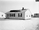
| Description: | Front view of a house to be used in an advertisement for home and subdivision development. The current address of this home is 3736 Sargent Street. |

| Date: | 12 16 1951 |
|---|---|
| Description: | Four young residents of Maple Bluff stand in front of the giant 32-foot-high Christmas display of a manger scene at the intersection of Charing Cross Road ... |
| Date: | 01 09 1952 |
|---|---|
| Description: | Exterior view of the William P. Robinson residence, located at 1923 North Avenue. |
| Date: | 07 04 1952 |
|---|---|
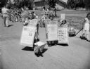
| Description: | Nancy, Glenn, and Tommy Lewis are shown costumed as sandwich board newspaper sections at the Shorewood Hills Fourth of July celebration. They won the most ... |
| Date: | 07 04 1952 |
|---|---|
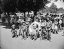
| Description: | Seven children dressed as cowboys 'portray the hardship of the 49ers trail.' They are, left to right: Bobby Curtis, John Curtis, John Levy, Bruce Levy, Vir... |
| Date: | 09 10 1952 |
|---|---|
| Description: | Group portrait of the principals and coaches from seven of the nine member schools of the Madison Suburban High School Sports League. |

| Date: | 09 13 1952 |
|---|---|
| Description: | View of the first of the thousands of people who toured the 18 new homes erected by 15 builders at Nakoma Road and the West Beltline. The Parade of Homes w... |

| Date: | 12 23 1953 |
|---|---|
| Description: | Aerial view of Crawford Heights looking northwest across Nakoma Road. The photograph shows Nakoma Road, the West Beltline, Cherokee School, and Midvale Bou... |

| Date: | 12 23 1953 |
|---|---|
| Description: | Aerial view of Crawford Heights looking north along Midvale Boulevard. The photograph shows Nakoma Road, the West Beltline, Cherokee School, and Midvale Bo... |

| Date: | 12 23 1953 |
|---|---|
| Description: | Aerial view of Crawford Heights looking northeast along Nakoma Road, across the West Beltline. The photograph shows Midvale Boulevard and Lake Mendota appe... |

| Date: | 12 22 1953 |
|---|---|
| Description: | Aerial photograph of Crawford Heights looking west along the West Beltline. The photograph shows Nakoma Road, Midvale Boulevard, Cherokee School, and the A... |
If you didn't find the material you searched for, our Library Reference Staff can help.
Call our reference desk at 608-264-6535 or email us at: