 Filter: Categories of Wisconsin Historical Images
Filter: Subject of Suburbs
Filter: Creator Name of Unknown
Filter: Categories of Wisconsin Historical Images
Filter: Subject of Suburbs
Filter: Creator Name of Unknown
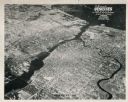
| Date: | 1948 |
|---|---|
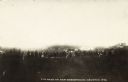
| Description: | Aerial view of downtown area, with the Fox River and neighboring suburbs. |
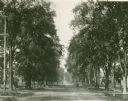
| Date: | 1896 |
|---|---|
| Description: | Jefferson Street south from Doty Street with trees lining the street. |
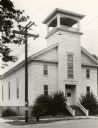
| Date: | |
|---|---|
| Description: | View towards front and left side of the First Presbyterian Church. |
| Date: | |
|---|---|
| Description: | View of Nakoma Road looking northeast, with several houses and trees, and automobiles parked on the street. There is a woman standing on the steps of a por... |
| Date: | 1939 |
|---|---|
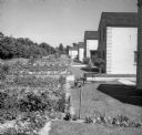
| Description: | View down row of back of houses. The backyards have gardens, and on the far left is a row of trees. |

| Date: | 1955 |
|---|---|
| Description: | Employees of the Wilson Sporting Goods Company in suburban Chicago are Bob Pickles and Ed Cronk. The men were representing the United Packinghouse Workers ... |
| Date: | 1920 |
|---|---|
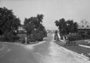
| Description: | A view of a residential area, featuring houses, a fork in the road, sidewalks, and trees. |

| Date: | 07 1955 |
|---|---|
| Description: | Beatrice (Bea) and Carson Gulley posing together at their 25th wedding anniversary party in their new home at 5701 Cedar Place. The home was located in the... |
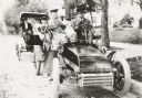
| Date: | 1903 |
|---|---|
| Description: | George S. Parker and family seated in their car, one of the first automobiles in Janesville. Behind them is a couple in another car. |

| Date: | 1920 |
|---|---|
| Description: | This map shows the Nakoma neighborhood in Madison including the "Proposed Golf Ground." The map reads: "Nakoma--the Suburb Superb." The map includes texts ... |

| Date: | 1969 |
|---|---|
| Description: | This map is pen and ink on paper and shows the location of churches, local streets, railroads, parks, Middleton, Shorewood Hills, Monona, Maple Bluff, McFa... |

| Date: | 1906 |
|---|---|
| Description: | This map shows ward boundaries, subdivisions, lot and block numbers and dimensions, house numbers, electric car lines, steam railways, and adjoining plat n... |

| Date: | 1893 |
|---|---|
| Description: | This map covers west to Wauwatosa, north to North Milwaukee, and south to South Milwaukee and shows street railways, city limits, parks, roads, railroads, ... |

| Date: | 1965 |
|---|---|
| Description: | This map is indexed for public buildings and includes a numbered key on the lower left side. The streets are labeled and Lake Michigan is labeled on the fa... |
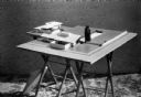
| Date: | 1933 |
|---|---|
| Description: | An architectural model of two houses for Broadacre City set up on a drafting table. |
| Date: | |
|---|---|
| Description: | View toward a group o people gathered at a vacant lot. There are dwellings in the distance. Caption reads: "Lot Sale on Sub-Division, Granton, Wis." |
If you didn't find the material you searched for, our Library Reference Staff can help.
Call our reference desk at 608-264-6535 or email us at: