Filter: Categories of Wisconsin Historical Images
Filter: Subject of Streetcars
Filter: Categories of Wisconsin Historical Images
Filter: Subject of Streetcars

| Date: | 12 12 1937 |
|---|---|
| Description: | Exterior view of old streetcar stabilized, adapted and furnished as living quarters. |
| Date: | 1915 |
|---|---|
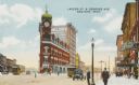
| Description: | Color postcard depicting residents, automobiles and streetcars. Caption reads: "Lapeer St. & Genesee Ave. Saginaw, Mich." |
| Date: | 1890 |
|---|---|
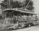
| Description: | Special open streetcar called the MARGUERITE, with elaborate lighting, decorations, movable chairs and other features. |

| Date: | 1918 |
|---|---|
| Description: | This map shows railroads, street car lines, wards, private claims, parks, railroad yards and depots, and cemeteries. The map is oriented with north to uppe... |

| Date: | 1931 |
|---|---|
| Description: | This map shows streets and highways, street car and bus lines, railroads, depots, schools, wards, and points of interest. The map is oriented with the nort... |
| Date: | |
|---|---|
| Description: | Exterior of the dinner menu offered by the dining car service of the New York Central and Hudson River railroad line, with a man in a bicorne, jacket, and ... |

| Date: | 1911 |
|---|---|
| Description: | Composite photograph of a trolley traversing Hillsboro's Main Street. Hillsboro did not actually have a streetcar; the image of the trolley was taken from ... |
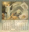
| Date: | 1893 |
|---|---|
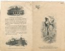
| Description: | 1893 calendar, with the months of August & September. Features an illustration of a woman holding a light. Around her are books, telescope, and other objec... |
| Date: | |
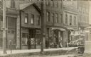
|---|---|
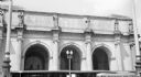
| Description: | Street view in the S. Sixth Street neighborhood of Walker's Point. The storefronts include the H.J. Heinz Co.; H. Mullen, a clothing and shoe store; J. Ger... |

| Date: | 1910 |
|---|---|
| Description: | Photographic postcard of the business district. On the right is a streetcar, in the center is a horse and buggy, along with pedestrians and several commerc... |
| Date: | |
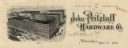
|---|---|
| Description: | Letterhead of the John Pritzlaff Hardware Company, with an elevated three-quarter view of the company building. |
| Date: | |
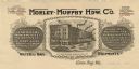
|---|---|
| Description: | Letterhead of the Morley-Murphy Hardware Company, with a three-quarter view of the company building and horse, streetcar, and rail traffic around it. |
| Date: | 1910 |
|---|---|
| Description: | Colorized view of Bridge Street, looking north from Spring Street intersection, in the central business district. The view includes stores, some with canva... |
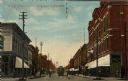
| Date: | 1910 |
|---|---|
| Description: | Color enhanced photographic postcard view of the "new" Barstow Street concrete arch bridge over the Eau Claire River. A street car is crossing the bridge. ... |

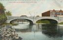
| Date: | 1912 |
|---|---|
| Description: | Black and white photographic postcard view of the Grand Avenue bridge across the Chippewa river, looking through the trusses along the streetcar tracks. Ca... |

| Date: | 1918 |
|---|---|
| Description: | View from sidewalk on the Capitol Square of band in a parade moving down Mifflin Street near the corner of Wisconsin Avenue. There is a sign for Collyer Ph... |

| Date: | 1901 |
|---|---|
| Description: | This map shows public schools, engine houses, railroads, street railways, city wards, parks, block numbers, and Lake Michigan. Also included are indexes, t... |

| Date: | 1904 |
|---|---|
| Description: | This map has three inset maps of Whitefish Bay, Cudahy, and South Milwaukee. This map depicts schools, engine houses, railroads, street railways, city ward... |

| Date: | 1904 |
|---|---|
| Description: | This map shows wards, schools, engine houses, railroads, street railways, block numbers, parks, roads, and Lake Michigan. Also included are indexes: Table ... |
If you didn't find the material you searched for, our Library Reference Staff can help.
Call our reference desk at 608-264-6535 or email us at: