 Filter: Categories of Wisconsin Historical Images
Filter: Subject of Street-railroads
Filter: Categories of Wisconsin Historical Images
Filter: Subject of Street-railroads

| Date: | 1917 |
|---|---|
| Description: | Shows property already platted (orange), public property (green), street railway (red lines), Lake Forest development area (red), and some landownership. T... |
| Date: | 1918 |
|---|---|
| Description: | Tramway and railroad leading into Solombola, Russia. In the foreground are a group of people, some sawing wood and others standing by the railroad. |

| Date: | 1888 |
|---|---|
| Description: | Shows ward divisions and street railways, as well as University of Wisconsin buildings, churches, and schools. Cataloged from copy with right and left edge... |
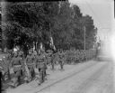
| Date: | 1918 |
|---|---|
| Description: | DESCRIPTION QUESTION: A group of American soldiers are marching down a street in Archangel [Archangelsk], Russia. Next to the flag barrier is a African Ame... |

| Date: | 1960 |
|---|---|
| Description: | Color coded map in pink, yellow, blue, and brown of Milwaukee County State and County trunk highways. The map includes a legend of symbols: "STEAM RAIL ROA... |

| Date: | 1938 |
|---|---|
| Description: | Color coded map in pink, yellow, blue, and brown of Milwaukee County State and County trunk highways. The map includes a legend of symbols: "STEAM RAIL ROA... |
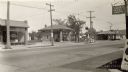
| Date: | 1930 |
|---|---|
| Description: | Businesses located near the intersection of Park and Lakeside Streets, before Park Street was widened. Identified from left, Madison Do-Nut Kitchen, Valvol... |
| Date: | |
|---|---|
| Description: | It's a day for celebration, just to be so cheering glad and everyone to know |

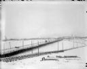
| Date: | 1909 |
|---|---|
| Description: | This map of Duluth and Superior was issued by the Duluth Street Railway Company and shows street railway routes in the cities, as well as lakes, bays, harb... |

| Date: | 1911 |
|---|---|
| Description: | This map of Duluth and Superior shows street car routes, railroads, ferries, some points of interest, and lighthouses. The bottom left of the map reads: "C... |

| Date: | 1948 |
|---|---|
| Description: | This map of Milwaukee and surrounding suburbs includes an index to the orange bus, rapid transit, street car, trackless trolley, and the green bus lines. T... |

| Date: | 1936 |
|---|---|
| Description: | Street map of the City of Milwaukee and surrounding suburbs indicating various mass transit lines. There is an index to Milwaukee streets at the right of t... |

| Date: | 1905 |
|---|---|
| Description: | Wells Street, between 16th and 18th Streets. Record photograph for a survey of Milwaukee street conditions, made to show the wooden cedar block pavement. T... |

| Date: | 1891 |
|---|---|
| Description: | This map shows railroads, electric street railways, block numbers, docks, roads, parks, light houses, selected buildings, and sites for manufacturers. The ... |

| Date: | 1894 |
|---|---|
| Description: | This map shows lot and block numbers, railroads, street car tracks, sewers, water mains, gas mains, paved streets, land owned by the Land & River Improveme... |
| Date: | 1893 |
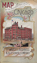
|---|---|
| Description: | Front cover of a brochure for Champion Mowers and Binders. Features a color illustration of the office building of the Warder, Bushnell and Glessner Compan... |
| Date: | 1910 |
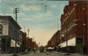
|---|---|
| Description: | Colorized view of Bridge Street, looking north from Spring Street intersection, in the central business district. The view includes stores, some with canva... |

| Date: | 1897 |
|---|---|
| Description: | Two maps that show cemeteries, schools, engine houses, railroads, street railways, wards, roads, parks, block numbers, and Lake Michigan. One map has wards... |

| Date: | 1912 |
|---|---|
| Description: | This map shows counties, roads, Lake Superior, Lake Michigan, and a portion of Illinois, Iowa, Minnesota, and Michigan. Also included is a list of railroad... |
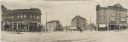
| Date: | 05 07 1907 |
|---|---|
| Description: | Panoramic view of the downtown towards Bascom Hall from the corner of the Capitol Square, showing Carroll, Mifflin, and State Streets. Several businesses c... |
If you didn't find the material you searched for, our Library Reference Staff can help.
Call our reference desk at 608-264-6535 or email us at: