 Filter: Categories of Wisconsin Historical Images
Filter: Subject of Signs and symbols
Filter: Year of 1700-1799
Filter: Categories of Wisconsin Historical Images
Filter: Subject of Signs and symbols
Filter: Year of 1700-1799
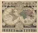
| Date: | 1745 |
|---|---|
| Description: | A two page world map featuring the Eastern and Western Hemispheres, as well as the northern and southern zodiacs. Additionally, the map is ordained with n... |
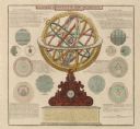
| Date: | 1745 |
|---|---|
| Description: | A two page illustration featuring a small globe in the center of numerous astrological spheres. Additionally, the representation features writing, in Lati... |
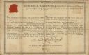
| Date: | 08 17 1778 |
|---|---|
| Description: | Document supporting the presentation of a medal presented by Frederick Haldimand, Captain-General and Governor in Chief of the Province of Quebec to Menomi... |
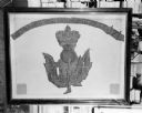
| Date: | 1719 |
|---|---|
| Description: | Photograph of a framed Scottish Historical Armorial Flag. |

| Date: | 1720 |
|---|---|
| Description: | Double hemispherical world map showing routes of Tasman, Magellan, Mendana, etc. Relief shown pictorially. Title in oak wreath cartouche. Map between four ... |

| Date: | 1740 |
|---|---|
| Description: | From Weigel's Atlas portatilis, oder, Compendieuse Vorstellung der gantzen Welt. Map of Europe. |

| Date: | 1712 |
|---|---|
| Description: | Engraved double-hemispherical world map by Moll, included in his atlas The world described, or, A new and correct sett of maps: shewing the kingdoms and st... |

| Date: | 1798 |
|---|---|
| Description: | Engraved and hand-colored map of Egypt. Map title appears on bottom left as a carving in stone next ... |

| Date: | 1709 |
|---|---|
| Description: | Map of North America, showing a few of the largest settlements, regions, islands, and a few rivers. The Great Lakes are depicted, but over-sized, and Calif... |
If you didn't find the material you searched for, our Library Reference Staff can help.
Call our reference desk at 608-264-6535 or email us at: