Filter: Categories of Wisconsin Historical Images
Filter: Subject of Roads
Filter: County of Grant
Filter: Categories of Wisconsin Historical Images
Filter: Subject of Roads
Filter: County of Grant

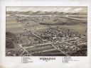
| Date: | 1869 |
|---|---|
| Description: | Birds-eye drawing of Boscobel, Grant County, depicts street names and street layouts, houses, rivers and trees. A reference key at the bottom of the map sh... |

| Date: | 1875 |
|---|---|
| Description: | Bird's-eye map of Platteville. |

| Date: | 1829 |
|---|---|
| Description: | Drawing of Cassville depicting a horse cart on the river's edge, with men and boats. |
| Date: | 1973 |
|---|---|
| Description: | Exterior of public school building, with a slide and trees. |
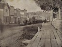
| Date: | 11 01 1896 |
|---|---|
| Description: | Canal Street less than a year before a fire swept through and destroyed many of these buildings on March 22, 1897, resulting in a loss of about $45,000. Pr... |
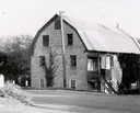
| Date: | 1956 |
|---|---|
| Description: | The stone building formerly housed the flour mill. The mill was established in 1852, but had pretty well gone out of business by 1895, by which time the po... |
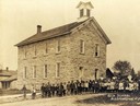
| Date: | 1900 |
|---|---|
| Description: | The "Rock School" building, with children and teachers posed outside. |
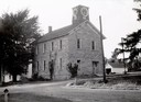
| Date: | 1956 |
|---|---|
| Description: | School known as the "old stone school," the first public school building in Bloomington. The clock tower replaced the former bell tower. |
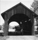
| Date: | 1935 |
|---|---|
| Description: | View of covered bridge above the Wisconsin River, 1 mile from Boscobel. |
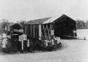
| Date: | 1930 |
|---|---|
| Description: | Ivey and Webb general store, with trees and a hill behind, and in front a man standing under the store's awning. |
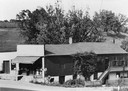
| Date: | 1900 |
|---|---|
| Description: | View across dirt road of two businesses. On the left is a two-story brick building with large windows which are painted with signs that say: "Habermann Buf... |
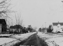
| Date: | 1908 |
|---|---|
| Description: | Snow-covered residential street with houses on each side. |
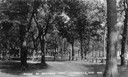
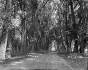
| Date: | |
|---|---|
| Description: | Park with tree-lined lane. Caption reads: "Scene in Riverside Park". |
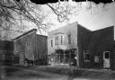
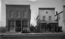
| Date: | 1910 |
|---|---|
| Description: | Three storefronts on a dirt road. A man, said to be Charles Grimm, is driving a horse and buggy. The building in the center is Feiker's photo studio. Near ... |
| Date: | 1965 |
|---|---|
| Description: | Rear view of a couple sitting in a horse-drawn buggy which is driving through a covered bridge at Stonefield Village. Buildings and trees are in the distan... |
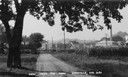
| Date: | |
|---|---|
| Description: | Caption reads: "View from the park". View down dirt road, with a large deciduous tree on the left side of the road, and a cornfield on the right. In the di... |
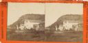
| Date: | 1885 |
|---|---|
| Description: | Stereograph of buildings in Glen Haven. Bluffs are in the background. |
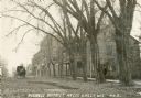
| Date: | 1909 |
|---|---|
| Description: | View of the business district with a horse and buggy traveling down the road. Caption reads: "Business District, Hazel Green, Wis." |
If you didn't find the material you searched for, our Library Reference Staff can help.
Call our reference desk at 608-264-6535 or email us at: