Filter: Categories of Wisconsin Historical Images
Filter: Subject of Roads
Filter: County of Columbia
Filter: Categories of Wisconsin Historical Images
Filter: Subject of Roads
Filter: County of Columbia

| Date: | 1936 |
|---|---|
| Description: | This map is red and black ink on tracing cloth and is oriented with north to the upper left. This hand-drawn map shows a central portion of the military ro... |
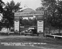
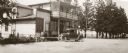
| Date: | 07 1927 |
|---|---|
| Description: | Car parked underneath the entrance gate to the Island Resort at the Wisconsin Dells, 25 miles from the Dells on Highway 12-16 near Mauston. Entrance gate a... |
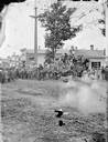
| Date: | 06 1868 |
|---|---|
| Description: | G.F. Bailey bandwagon, with band, and central elevated figure of Mazeppa legend on Broadway in Kilbourn City. Hitch is an Asiatic elephant led by paired dr... |
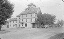
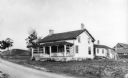
| Date: | |
|---|---|
| Description: | Exterior view of Hile House Hotel. There is a belvedere in the center of the roof. |
| Date: | |
|---|---|
| Description: | View across unpaved road towards Glen Cottage, later Crandall Hotel. |
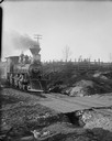
| Date: | |
|---|---|
| Description: | Kilbourn; little wood burner locomotive (train engine) at crossing. |

| Date: | 1870 |
|---|---|
| Description: | Bird's-eye map of Kilbourn City, now known as Wisconsin Dells. Kilbourn City was platted in the 1850s and received a boost when the La Crosse and Milwaukee... |

| Date: | 1874 |
|---|---|
| Description: | Bird's-eye map of Lodi, with inset of Public School. Includes index of churches and points of interest. |
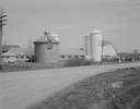
| Date: | 04 27 1945 |
|---|---|
| Description: | Wisconsin Conference of Seventh Day Adventists farm buildings including barns, three silos and a corn crib on Duborg Road off of Highway 16 west of Columbu... |
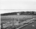
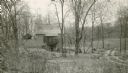
| Date: | 11 01 1937 |
|---|---|
| Description: | View from the road of the State Experimental Game and Fur Farm. |
| Date: | 1877 |
|---|---|
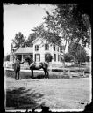
| Description: | View of Dr. Blake's (probably Samuel M.) house in Lodi or Prairie du Sac with a white picket fence in front of it. A man is standing in the grass in front ... |
| Date: | 1877 |
|---|---|
| Description: | A dirt road leads to Dr. Blake's (probably Samuel M.) frame house in Lodi or Prairie du Sac. A family is under a tree near a wooden fence. On the right is... |
| Date: | 1923 |
|---|---|
| Description: | Wilson's Tavern, north of the point where the road from Black Hawk enters Trunk Highway 60. Built by John Wilson on Wilson Creek. |
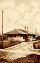
| Date: | 1908 |
|---|---|
| Description: | View down unpaved road towards the railroad station. Caption reads: "R. R. Station, Columbus, Wis." |
| Date: | 1910 |
|---|---|
| Description: | Lawn, trees and blooming flowers in front of St. Mary's Hospital. Caption reads: "St. Mary's Hospital, Columbus, Wis." |
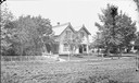
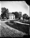
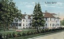
| Date: | 1930 |
|---|---|
| Description: | View of a house among trees, and the surrounding landscape. |
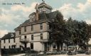
| Date: | 1905 |
|---|---|
| Description: | View from road of the Hile House, Kilbourn (now Wisconsin Dells). There is a belvedere in the center of the roof. Caption reads: "Hile House, Kilbourn, Wis... |

| Date: | 1921 |
|---|---|
| Description: | View from across road of the Hile House. This is where the actress and Confederate spy Belle Boyd died on June 11, 1900, in the front room, over the office... |

| Date: | 1912 |
|---|---|
| Description: | View from road of the Briggs Hotel, which burned down in 1913. |
If you didn't find the material you searched for, our Library Reference Staff can help.
Call our reference desk at 608-264-6535 or email us at: