Filter: Categories of Wisconsin Historical Images
Filter: Subject of Rivers
Filter: Categories of Wisconsin Historical Images
Filter: Subject of Rivers
| Date: | |
|---|---|
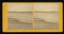
| Description: | View from shoreline towards eight men trout fishing on the Brule River. |
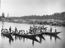
| Date: | 1900 |
|---|---|
| Description: | Log driving crew on river in five bateaux. In the background on the left is a bridge. |

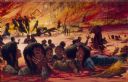
| Date: | 09 1871 |
|---|---|
| Description: | Bird's-eye view of Peshtigo, before it was destroyed by fire on the night of October 8, 1871. |

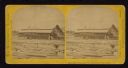
| Date: | 1907 |
|---|---|
| Description: | Buildings and storefronts in town near bridge and river. |
| Date: | 1908 |
|---|---|
| Description: | The Yahara River from Williamson Street with Lake Monona in the background. House & Barn pictured is located at 601 Riverside Drive. |
| Date: | 1856 |
|---|---|
| Description: | Painting by S.M. Brookes of the Wisconsin Heights Battlefield. |
| Date: | 1886 |
|---|---|
| Description: | Log jam on the St. Croix River at the Head of the Dalles. The jam was about five miles long, and 50,000,000 board feet of white pine was piled up. |

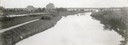
| Date: | 1910 |
|---|---|
| Description: | View down the canal, with buildings along the shoreline, and a boat coming down the canal. |

| Date: | 1864 |
|---|---|
| Description: | This map shows pictorially a section of bracketdam, section of tree dam, and crib of stone. This map was prepared by order of General Joseph Bailey and is ... |

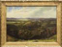
| Date: | 1856 |
|---|---|
| Description: | This landscape painting by Samuel Marsden Brookes and Thomas H. Stevenson depicts a broad view of the confluence of Bad Axe and Mississippi Rivers; site of... |

| Date: | 1866 |
|---|---|
| Description: | Full-length portrait of Morgan L. Martin standing in a landscape, with a dog sitting at his feet. |

| Date: | 1870 |
|---|---|
| Description: | This bird's-eye-view map shows roads, a river with boats, and homes. The bottom margin of the map includes an index. |
| Date: | 1867 |
|---|---|
| Description: | Mill dam and sash factory. "The Northwester Gateway. Excursion to Lake Superior, June 1867. Photographed and Published by J. Carbutt, 131 Lake St., Chicago... |
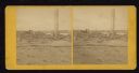
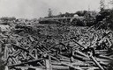
| Date: | 1871 |
|---|---|
| Description: | Ruins of building showing smokestack still standing after the Peshtigo fire. A group of men are standing on the left. |

| Date: | 10 1852 |
|---|---|
| Description: | Landscape view of the river looking downstream from Fort Snelling, Minnesota Territory. An expanse of placid river water fills the center of the drawing an... |
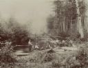
| Date: | 1900 |
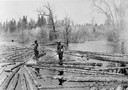
|---|---|
| Description: | Log pond with two lumberjacks walking on the floating logs and sorting them in the Peshtigo River area. |

| Date: | 1881 |
|---|---|
| Description: | Bird's-eye map of Marinette, with insets. |
If you didn't find the material you searched for, our Library Reference Staff can help.
Call our reference desk at 608-264-6535 or email us at: