 Filter: Categories of Wisconsin Historical Images
Filter: Subject of Rivers
Filter: County of Jefferson
Filter: Categories of Wisconsin Historical Images
Filter: Subject of Rivers
Filter: County of Jefferson

| Date: | 1880 |
|---|---|
| Description: | Bird's-eye view of Jefferson on the Rock River. |

| Date: | 1885 |
|---|---|
| Description: | Bird's-eye view of Watertown with indexed points of interest. |

| Date: | 1870 |
|---|---|
| Description: | Birds eye drawing of Fort Atkinson, Jefferson County, depicts street names and street layouts, houses, trees, Rock River and Bark River. A reference key at... |

| Date: | 1870 |
|---|---|
| Description: | Although the first European settlement in Jefferson was in 1836, the Village of Jefferson was first incorporated as a city in 1878. Made eight years earlie... |

| Date: | 1867 |
|---|---|
| Description: | Bird's-eye map of Watertown on the Rock River, "drawn from nature." |

| Date: | 1893 |
|---|---|
| Description: | This photocopy of a bird’s-eye-view map shows illustrated houses and various buildings. Streets and the Rock River are labeled. An index to points of inter... |

| Date: | 1893 |
|---|---|
| Description: | Bird's-eye map of Jefferson, looking north. Crayfish River at left and center, Rock River from upper center to bottom center, joins at left of center; thir... |

| Date: | 1879 |
|---|---|
| Description: | Bird's-eye map of Lake Mills. |
| Date: | 1910 |
|---|---|
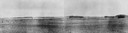
| Description: | View of the Crawfish River in the vicinity of Aztalan. |
| Date: | |
|---|---|
| Description: | Elevated view of Indian village, along a river, (in a painted reconstruction) during an Indian ceremony. |
| Date: | |
|---|---|
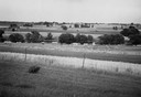
| Description: | View from shoreline across Crawfish River, with foliage and a barbed wire fence in the foreground. |

| Date: | 1955 |
|---|---|
| Description: | Artist's conception of ancient village of Aztalan, fortified with high walls surrounding it. |
| Date: | 1945 |
|---|---|
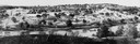
| Description: | Field prior to the park's reconstruction, with a fence in the foreground. A river is at the bottom of the hill. |
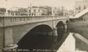
| Date: | 1910 |
|---|---|
| Description: | View of a river and Main Street bridge above the river. Commercial buildings line the street on the opposite side of the bridge. Caption reads: "Main St. B... |
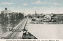
| Date: | 1910 |
|---|---|
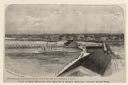
| Description: | Elevated view of the Northwestern Manufacturing Company plant. Caption reads: "Birds-eye View showing Northwestern Mfg. Co.'s Plant, Fort Atkinson, Wis." |
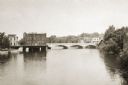
| Date: | 1915 |
|---|---|
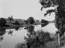
| Description: | View across water towards the Main Street Bridge over the Rock River. |
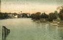
| Date: | 1909 |
|---|---|
| Description: | View of the Rock River, with boathouses along the right shoreline, and buildings in the distance on the left at a bend in the river. Pilings are in the for... |
| Date: | 1915 |
|---|---|
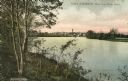
| Description: | Distant view of Fort Atkinson from the shoreline of the Rock River. Caption reads: "Fort Atkinson, Wis., from Rock River." |
| Date: | 1876 |
|---|---|
| Description: | Elevated view of Fort Howard taken from Elmore and Kelly's Elevator with the dam and river. A tugboat is in the river above the dam. Caption reads: "View o... |
If you didn't find the material you searched for, our Library Reference Staff can help.
Call our reference desk at 608-264-6535 or email us at:
