 Filter: Categories of Wisconsin Historical Images
Filter: Subject of Real estate development
Filter: Categories of Wisconsin Historical Images
Filter: Subject of Real estate development
| Date: | 1936 |
|---|---|
| Description: | View from lawn of curved residential street lined with recently constructed housing and lampposts. A car sits in a driveway of a house on the left, and fur... |

| Date: | 1936 |
|---|---|
| Description: | Recently constructed residential housing as viewed from a hill. A fence is in the foreground. Porches, backyards, and small garages lead down to the Villag... |

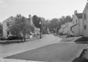
| Date: | 1936 |
|---|---|
| Description: | View up residential street with newly constructed houses, young trees and lampposts. Men in suits and hats walk along the sidewalk. A speed limit sign is o... |
| Date: | 06 01 1950 |
|---|---|
| Description: | City Manager Leonard G. Howell turns the first shovelful of dirt for the first of eleven houses to be built by Madison builders under the Good American Hom... |

| Date: | 1890 |
|---|---|
| Description: | Letterhead for Moulton, Moran & Co. The logo shows North America and depicts Superior as the center of a hub with spokes going to Russia, to China and Japa... |
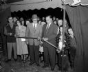
| Date: | 09 15 1950 |
|---|---|
| Description: | Madison's first home show in thirteen years was officially opened by Acting Manager George Forster when he cut the ribbon at the entrance to the exhibit ar... |

| Date: | 03 12 1952 |
|---|---|
| Description: | Keen Manufacturing Company, 2661 East Washington Avenue. The photgraph was taken for Richard Beichl, real estate agent, and is the site of the East Madison... |
| Date: | |
|---|---|
| Description: | Letterhead of Baldwin & Killen Lands and W.H. Killen & Company, dealers of farm, lumber, and mineral lands, from Appleton, Wisconsin, with an image on the ... |

| Date: | 11 05 1954 |
|---|---|
| Description: | Front exterior view of a ranch-style house newly built by C.M. Wildenberg. The building is described as a "26'x42' three bedroom ranch." It is located at 5... |

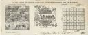
| Date: | 1877 |
|---|---|
| Description: | This map shows the lands in northern Wisconsin owned by Cornell University that were for sale. Text on the map encourages interested buyers to seek more in... |

| Date: | 1914 |
|---|---|
| Description: | This map is a photostat copy from the original 1829 map in the War Department. The map shows location of Fort Howard, lots, land claims of Jacques Porlier ... |
| Date: | 06 12 1956 |
|---|---|
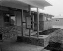
| Description: | Planter boxes are one of the features in this house located at 5509 Russett Road. The house was built by built by Robert Shaw for the 1956 Parade of homes. |
| Date: | 06 12 1956 |
|---|---|
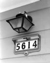
| Description: | This house in the 1956 Parade of Homes in Meadowood with its illuminated device for showing the house numbers has been wired to the exact standards of the ... |
| Date: | 06 12 1956 |
|---|---|
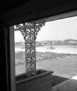
| Description: | Ornamental ironwork based in a planter holds up the corner of a roof overhang at 5609 Russett Rd. The house was built by built by Charles Fry for the 195... |
| Date: | 06 12 1956 |
|---|---|
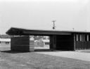
| Description: | One of the houses in the Parade of Homes was built with a carport. This located at 5610 Raymond Rd. The house was built by built by Hermann E. Postweiler ... |

| Date: | 07 1988 |
|---|---|
| Description: | "Theresa Village President, Martin Koll, presided at the ribbon-cutting at the River View Mobile Home Park." |
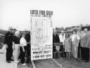
| Date: | 03 1998 |
|---|---|
| Description: | "Village officials help kick off Valley Estates Subdivision." |
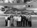
| Date: | 03 1998 |
|---|---|
| Description: | "Progress on Valley Estates Subdivision." |

| Date: | 07 15 1957 |
|---|---|
| Description: | Cars park in a new parking lot at the former site of Washington School at 217 North Broom Street. |

| Date: | 1835 |
|---|---|
| Description: | This map is pen-and-ink on paper. The map shows landowners in "Milwalky" or present day Milwaukee. Includes "list of property offered to Mr. Walker". The m... |
If you didn't find the material you searched for, our Library Reference Staff can help.
Call our reference desk at 608-264-6535 or email us at: