 Filter: Categories of Wisconsin Historical Images
Filter: Subject of Real estate development
Filter: County of Milwaukee
Filter: Categories of Wisconsin Historical Images
Filter: Subject of Real estate development
Filter: County of Milwaukee
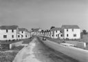
| Date: | 1936 |
|---|---|
| Description: | View down road of mass-produced residential housing with farm in background. |

| Date: | |
|---|---|
| Description: | A man wearing a tie stands next to an industrial trailer used for clearing of land. The side of the trailer reads "BROS" and there are other vehicles in th... |

| Date: | |
|---|---|
| Description: | A man in a hat and overalls leans over a trench or ditch digger, looking down into the excavated area. Pipes, an automobile, and a building are in the back... |
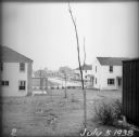
| Date: | 07 05 1938 |
|---|---|
| Description: | A recently planted sapling in the backyard of an empty house, with other houses and roads visible in the background. |

| Date: | |
|---|---|
| Description: | Commercial buildings, roads, cars parked in lots, as seen from the snow-covered lawn of the Village Hall. |
| Date: | |
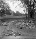
|---|---|
| Description: | Rocks placed to control the flow of Dale Creek. A house is visible in the background. This picture was likely taken as a study of the water drainage in ear... |
| Date: | 1936 |
|---|---|
| Description: | View from lawn of curved residential street lined with recently constructed housing and lampposts. A car sits in a driveway of a house on the left, and fur... |

| Date: | 1936 |
|---|---|
| Description: | Recently constructed residential housing as viewed from a hill. A fence is in the foreground. Porches, backyards, and small garages lead down to the Villag... |

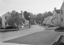
| Date: | 1936 |
|---|---|
| Description: | View up residential street with newly constructed houses, young trees and lampposts. Men in suits and hats walk along the sidewalk. A speed limit sign is o... |

| Date: | 1835 |
|---|---|
| Description: | This map is pen-and-ink on paper. The map shows landowners in "Milwalky" or present day Milwaukee. Includes "list of property offered to Mr. Walker". The m... |

| Date: | 06 1837 |
|---|---|
| Description: | Pen-and-ink on paper. Shows riverside property west of the Milwaukee River. Inscribed by several early Milwaukee settlers, including Henry W. Cleveland, Cy... |

| Date: | 1939 |
|---|---|
| Description: | This is a zoning map of Wauwatosa with a key of districts including agricultural, resident, business, commercial, and industrial. The map features labeled ... |
If you didn't find the material you searched for, our Library Reference Staff can help.
Call our reference desk at 608-264-6535 or email us at: