 Filter: Categories of Wisconsin Historical Images
Filter: Subject of Railroads
Filter: Year of 2000-Present
Filter: Categories of Wisconsin Historical Images
Filter: Subject of Railroads
Filter: Year of 2000-Present

| Date: | 2007 |
|---|---|
| Description: | This map of Cedarbug is a bird's-eye map with 8 inset views and an index. The map is a print out of the original map dated 1892 held at the Cedarburg Cultu... |
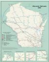
| Date: | 2000 |
|---|---|
| Description: | This map shows railroads by operating freight and government agencies, Amtrak stations, ports, rail lines out of service, rail banks, and Rails-to-Trails. ... |

| Date: | 02 22 2012 |
|---|---|
| Description: | Northwesterly view of the railroad corridor in the Village of Blue Mounds. There is a dense growth of trees in the area. |

| Date: | 2008 |
|---|---|
| Description: | This double sided map shows roads, railroads, biking trails, civil townships, parks, wildlife refuges, town halls, and hospitals. The region map covers par... |

| Date: | 2000 |
|---|---|
| Description: | This map shows the industrial area along the Menominee River and canals. Industrial buildings are shown in orange and labeled in red. Other areas are shown... |
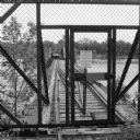
| Date: | 06 2014 |
|---|---|
| Description: | View through chain-link fence towards the railroad trestle that spans the Wisconsin River, worn with age, and split apart in the middle. There is a padlock... |
If you didn't find the material you searched for, our Library Reference Staff can help.
Call our reference desk at 608-264-6535 or email us at: