 Filter: Categories of Wisconsin Historical Images
Filter: Subject of Railroads
Filter: Categories of Wisconsin Historical Images
Filter: Subject of Railroads

| Date: | 1879 |
|---|---|
| Description: | Bird's-eye map of Two Rivers. |

| Date: | 1879 |
|---|---|
| Description: | Bird's-eye view of Viroqua, county seat of Vernon County. |

| Date: | 1896 |
|---|---|
| Description: | Bird's-eye view of Washburn, with twenty vignettes around side, water in foreground with docks and lumber corral. Thirty-three locations identified in key ... |

| Date: | 1910 |
|---|---|
| Description: | Bird's-eye view looking east, with Washburn Harbor at center and Chequamegon Bay in Lake Superior covering most of the upper image. Streets with buildings... |

| Date: | 1874 |
|---|---|
| Description: | Bird's-eye view of Waukesha, looking southwest, with insets of State Industrial School, Court House, and Fountain Spring House. |

| Date: | 1879 |
|---|---|
| Description: | This map is a bird's-eye view of Wausau, the County Seat of Marathon County. The map features an index of points of interest. |

| Date: | 1870 |
|---|---|
| Description: | Bird's-eye view of Whitewater, with insets. |

| Date: | 1860 |
|---|---|
| Description: | Bird's-eye view of Janesville from the High School building. |

| Date: | 1857 |
|---|---|
| Description: | From Judge Smith Addition, 5th Ward, looking north, toward the city. Drawing is an elevated view of field and plank fence in foreground, road to the left a... |

| Date: | 1886 |
|---|---|
| Description: | Bird's-eye view of Milwaukee from Bay View. |
| Date: | 04 20 1929 |
|---|---|
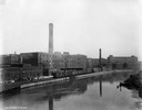
| Description: | Railroad tracks and waterway outside International Harvester's Deering Works. The Deering Works was owned by the Deering Harvester Company before 1902. |

| Date: | 1885 |
|---|---|
| Description: | Ore dock of the Milwaukee, Lake Shore, and Western Railroad, with a pile of logs in the foreground and docked ships in the background. |

| Date: | 1855 |
|---|---|
| Description: | Part of George Harrison's "Map of the City of Madison," showing the development of the isthmus and the small size of the second Capitol (54' x 104') in com... |

| Date: | 1892 |
|---|---|
| Description: | Bird's-eye view of Chicago, with ships in the Lake Michigan harbor. |
| Date: | 1914 |
|---|---|
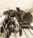
| Description: | Elevated view of the wreck of a Chicago and Northwestern Railroad train at Corliss. A large crowd of men are watching as a Bucyrus crane is lifting a car b... |

| Date: | 1910 |
|---|---|
| Description: | Wisconsin Central Railway locomotive #2035 and a work train on a track clean-up assignment. Locomotive #102 was built by the Baldwin Locomotive Works in 18... |
| Date: | 1907 |
|---|---|
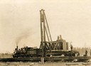
| Description: | Wisconsin Central locomotive No #50 and pile driver No #2 working near Owen. Men stand on and around the tracks. |
| Date: | 1880 |
|---|---|
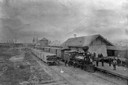
| Description: | Elevated view of the Wisconsin Central Railroad passenger depot at Stuntz Avenue. A group of people stand on the platform and near the locomotive between t... |
If you didn't find the material you searched for, our Library Reference Staff can help.
Call our reference desk at 608-264-6535 or email us at:

