 Filter: Categories of Wisconsin Historical Images
Filter: Subject of Railroads
Filter: Subject of cities and towns
Filter: Categories of Wisconsin Historical Images
Filter: Subject of Railroads
Filter: Subject of cities and towns
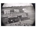
| Date: | 1873 |
|---|---|
| Description: | Elevated view of several men, some of whom may be railroad workers, posing in front of a Minnesota and St. Paul wood-burning engine at a train crossing. Th... |
| Date: | 1923 |
|---|---|
| Description: | Railway depot and railyard. Caption reads: "Depot and Yards Fitchburg, Wis." |
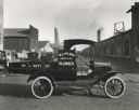
| Date: | 1920 |
|---|---|
| Description: | Ford truck of Madison plumber W.J. Hyland parked outdoors. |

| Date: | 1881 |
|---|---|
| Description: | Bird's-eye map of Marinette, with insets. |
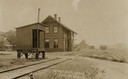
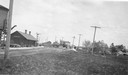
| Date: | 1909 |
|---|---|
| Description: | Exterior shot of the Blue River depot. Five men are standing outside the building. There is a Wells Fargo cart on the platform. |

| Date: | 1908 |
|---|---|
| Description: | Colored map showing a panoramic view of Madison in great detail. The Wisconsin State Capitol is located at the center, with Lake Mendota in the background ... |
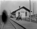
| Date: | 1925 |
|---|---|
| Description: | Railroad depot taken as part of a survey by the Wisconsin Power and Light Company to promote economic development by emphasizing available buildings and bu... |
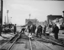
| Date: | 10 27 1936 |
|---|---|
| Description: | Railroad construction crew working on a Chicago & Northwestern Railroad crossing, looking west up the 400 and 500 blocks of East Wilson Street. |

| Date: | 1886 |
|---|---|
| Description: | Bird's-eye view of Ashland, on the shores of Lake Superior, with insets of The Apostle Islands Chequamagon Bay & Ashland, and Distances from Ashland. |

| Date: | 1856 |
|---|---|
| Description: | This map show the surveyed southern part of state and includes "profile of the Milwaukee and Mississippi Rail Road." Counties are shown in pink, green, blu... |

| Date: | 1886 |
|---|---|
| Description: | This map shows U.S. land offices, completed railroads, railroad land grant limits, lakes, rivers, and Indian reservations. Communities, lakes, and rivers a... |
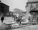
| Date: | 10 27 1936 |
|---|---|
| Description: | Construction crew working on a Chicago & Northwestern Railroad crossing, looking northwest along the 100 block of South Blair Street. |

| Date: | 1874 |
|---|---|
| Description: | This map shows lakes, rivers, state, county, and town boundaries, as well as railroads completed, in progress, and contemplated. The map includes a color d... |

| Date: | 1871 |
|---|---|
| Description: | Bird's-eye view of the Chicago fire of October 8, 1871. The hand-colored lithograph was published by Currier and Ives. |

| Date: | 1856 |
|---|---|
| Description: | View looking west from Lake Michigan with several steam ships and sailing vessels in harbor. There is a lighthouse to left of center, along shoreline. |

| Date: | 1891 |
|---|---|
| Description: | Bird's-eye map of Wausau, looking north with ninety-eight businesses, industries, churches, schools, and civic buildings identified in location key below i... |
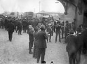
| Date: | 1917 |
|---|---|
| Description: | Twelve piece brass band playing at a railroad station during the "Union Pacific Preparedness Special Campaign." |
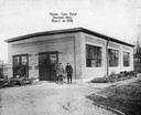
| Date: | |
|---|---|
| Description: | Two men stand in front of the Hand Car Shop, which was built in 1916. |
If you didn't find the material you searched for, our Library Reference Staff can help.
Call our reference desk at 608-264-6535 or email us at:

