 Filter: Categories of Wisconsin Historical Images
Filter: Subject of Railroads
Filter: County of Columbia
Filter: Categories of Wisconsin Historical Images
Filter: Subject of Railroads
Filter: County of Columbia
| Date: | |
|---|---|
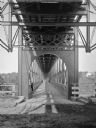
| Description: | Interior of railroad bridge, with walkway below. There is a man standing on the left at the railing of the walkway. |
| Date: | |
|---|---|
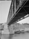
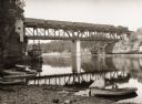
| Description: | View of the river and the underside of a railroad bridge at Kilbourn. There is a building in the background on the right just above the cliffs along the ri... |
| Date: | |
|---|---|
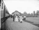
| Description: | Kilbourn railroad station looking north. A crowd of people are standing on the platform. Carriages are parked behind the station building. |
| Date: | |
|---|---|
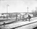
| Description: | Three men are laying rail on snow-covered ground at the Kilbourn railroad station. |
| Date: | |
|---|---|
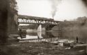
| Description: | Chicago, Milwaukee and St. Paul passenger train on Kilbourn railroad bridge. "Apollo No. 1" steamboat below bridge, with musicians in bow. Various launch b... |
| Date: | |
|---|---|
| Description: | Bridge over river with railroad train. "Apollo No. 1" steamboat under bridge. Boats are along the shoreline. |
| Date: | |
|---|---|
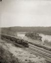
| Description: | Elevated view of a train running parallel to the river, past the Ink Stand. Several people are standing along the tracks and waving. |
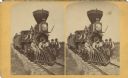
| Date: | |
|---|---|
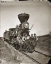
| Description: | Men posed on the front cowcatcher, or pilot, of a wood burning locomotive, with a few cars attached. Three other men pose on the locomotive. |
| Date: | |
|---|---|
| Description: | Kilbourn; little wood burner locomotive (train engine) at crossing. |

| Date: | 1868 |
|---|---|
| Description: | This 1868 birds-eye view depicts the buildings, streets, railroad, vegetation and topography of Columbus, Wisconsin. The high school, cemetery, railroad de... |

| Date: | 1874 |
|---|---|
| Description: | Bird's-eye map of Lodi, with inset of Public School. Includes index of churches and points of interest. |
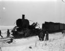
| Date: | 01 11 1948 |
|---|---|
| Description: | The remains of the Milwaukee Road railroad engine of the Portage to Madison passenger train, which exploded and derailed south of Arlington in Columbia Cou... |

| Date: | 1878 |
|---|---|
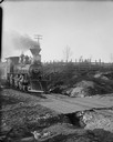
| Description: | View from riverbank of the Chicago Milwaukee and St. Paul railroad locomotive no. 142 on the Kilbourn bridge. |
| Date: | |
|---|---|
| Description: | Men posed on the front cowcatcher, or pilot, of a wood burning locomotive, with a few cars attached. Three other men pose on the locomotive. |

| Date: | 1861 |
|---|---|
| Description: | This 1861 map of Columbia County, Wisconsin, shows the township and range grid, towns, sections, cities and villages, railroads, roads, property owners and... |

| Date: | 1930 |
|---|---|
| Description: | This pictorial map from the first half of the 20th century shows the landmarks, highways, rail lines, and cities and villages in the vicinity of the Wiscon... |

| Date: | 1935 |
|---|---|
| Description: | This 1935 map shows the Wisconsin River from a point approximately 4 miles south of the city of Wisconsin Dells north to Duck Creek in Adams County. Sectio... |

| Date: | 1905 |
|---|---|
| Description: | Shows railroads, roads, post offices, creeks, lakes, and cities. Includes chart of deposits and total resources from the years 1890 to 1905. "First Natio... |

| Date: | 1877 |
|---|---|
| Description: | Shows land ownership by name, churches, schools, farm houses, wagon roads, railroads. Includes directory of businesses for Columbus, Portage, Doylestown, W... |

| Date: | 1856 |
|---|---|
| Description: | This map shows plat of town, local streets, railroads, projected railroads, residential buildings, mills, and part of the Crawfish River. The map includes ... |
If you didn't find the material you searched for, our Library Reference Staff can help.
Call our reference desk at 608-264-6535 or email us at: