 Filter: Categories of Wisconsin Historical Images
Filter: Subject of Quarries and quarrying
Filter: County of Dane
Filter: Categories of Wisconsin Historical Images
Filter: Subject of Quarries and quarrying
Filter: County of Dane

| Date: | 05 14 1943 |
|---|---|
| Description: | Truck-mounted Catepillar engine/compressor parked at Albert W. Gallagher Quarry on Highway 51 near the airport. The photograph was taken for Nagle-Hart Tra... |

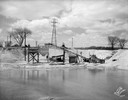
| Date: | 10 21 1931 |
|---|---|
| Description: | Elevated view of a colony of squatters in Sunset Point (Hoyt Park, Quarry Park), former quarry site. Home of John & Lottie Corcoran from 1924-1994. |
| Date: | 05 04 1929 |
|---|---|
| Description: | Carl E. & Paul G. Roth gravel pit with conveying equipment. |

| Date: | 05 04 1929 |
|---|---|
| Description: | View from the east towards the Carl E. & Paul G. Roth gravel pit, showing conveying equipment. |

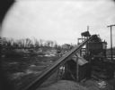
| Date: | 04 19 1928 |
|---|---|
| Description: | Crushing and Loading equipment at a gravel pit. |

| Date: | 04 19 1928 |
|---|---|
| Description: | Crushing and Loading equipment at gravel pit. |

| Date: | 04 19 1928 |
|---|---|
| Description: | Crushing and loading machinery at a gravel pit. |

| Date: | 04 09 1945 |
|---|---|
| Description: | A.M. Mickelson, 10 N. Owen Dr., inspecting the scene of the explosion at the base of Sunset point where three Madison boys were badly burned while playing ... |
| Date: | 02 16 1931 |
|---|---|
| Description: | Wisconsin Foundry & Machine Co. conveyor belt loading gravel into hopper which is filling a C.E. & P.A. Roth truck at their gravel pit, 1910 Roth Street ne... |
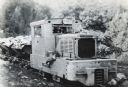
| Date: | 12 22 1937 |
|---|---|
| Description: | Brookville locomotive pulling dump cars in a rock quarry owned by General Refractories Company. Two men can be seen sitting inside through the front window... |
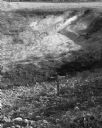
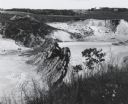
| Date: | 10 05 1963 |
|---|---|
| Description: | View down into a large gravel pit. A small, wooden cross is in the foreground. |

| Date: | 1867 |
|---|---|
| Description: | This 1867 manuscript map by Increase Lapham shows the topography and geology of the Blue Mounds region in the Town of Brigham in Iowa County and the towns ... |
| Date: | 1963 |
|---|---|
| Description: | Sand and gravel pit used by the Dane County highway department as a source of supply. |

| Date: | 1902 |
|---|---|
| Description: | This map is watercolor and pen on paper and relief shown by contours. The map reads: "Contour interval 10 feet." Shown on the map are geological features a... |

| Date: | 03 20 1986 |
|---|---|
| Description: | View of Quarry Drive, a sunken path lined with trees, near Mendota Heights. Branches and stones obstruct the pathway. |

| Date: | |
|---|---|
| Description: | View of Sid, with a cigar in his mouth and holding a club, sitting on an animal-skin rug outdoors in what may be a quarry. He is wearing a rag mop on his h... |
If you didn't find the material you searched for, our Library Reference Staff can help.
Call our reference desk at 608-264-6535 or email us at: