 Filter: Categories of Wisconsin Historical Images
Filter: Subject of Public utilities
Filter: Categories of Wisconsin Historical Images
Filter: Subject of Public utilities
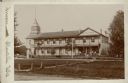
| Date: | 1897 |
|---|---|
| Description: | A cabinet card photograph of the Montello House Hotel. The two-story brick building has a gable fronted wing on the right and a shingled wooden tower on th... |
| Date: | 1974 |
|---|---|
| Description: | This blue line map show gas services and county boundaries. Includes a legend of company names in lower left hand corner. |
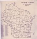
| Date: | 11 1973 |
|---|---|
| Description: | This map shows the cities, county boundaries and telephone exchange locations. The map includes a numbered list of telephone companies. |
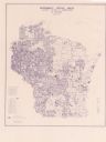
| Date: | 06 1975 |
|---|---|
| Description: | This map shows electrical utilities and cooperatives throughout the state, as well as cities and county boundaries. The bottom left corner of the map inclu... |

| Date: | 1973 |
|---|---|
| Description: | This map is 1 of 7 and includes a location map and township diagram in the margins. The map includes a key of land type: Residential (yellow), Commercial (... |

| Date: | 1973 |
|---|---|
| Description: | This map is 2 of 7 and includes a location map and township diagram in the bottom margin. The map includes a key of land type: Residential (yellow), Commer... |

| Date: | 1973 |
|---|---|
| Description: | This map is 3 of 7 and includes a location map and township diagram in the margins. The map includes a key of land type: Residential (yellow), Commercial (... |

| Date: | 1973 |
|---|---|
| Description: | This map is 4 of 7 and includes a location map and township diagram in the left margin. The map includes a key of land type: Residential (yellow), Commerci... |

| Date: | 1973 |
|---|---|
| Description: | This map is 5 of 7 and includes a location map and township diagram in the left margin. The map includes a key of land type: Residential (yellow), Commerci... |

| Date: | 1973 |
|---|---|
| Description: | This map is 6 of 7 and includes a location map and township diagram in the bottom margin. The map includes a key of land type: Residential (yellow), Commer... |

| Date: | 1973 |
|---|---|
| Description: | This map is 7 of 7 and includes a location map and township diagram in the left margin. The map includes a key of land type: Residential (yellow), Commerci... |

| Date: | |
|---|---|
| Description: | View across water towards the shoreline of the eastern isthmus of Madison, including the MG&E power plant smokestacks. A group of people appear to be fishi... |

| Date: | |
|---|---|
| Description: | High humidity and low temperatures cause massive steam clouds to billow from the stacks of Wisconsin Power and Light Company behind a house on Jenifer Stre... |

| Date: | |
|---|---|
| Description: | View alongside railroad tracks looking towards an approaching steam locomotive. In the background on the right is a power plant with smokestacks. |

| Date: | 1955 |
|---|---|
| Description: | A very large white oak tree standing along County Trunk Highway S dwarfs a utility pole nearby. There is a barn across a field in the far background. The t... |

| Date: | 07 24 1910 |
|---|---|
| Description: | View of a power plant and dam on the Fox River. Caption reads: "High Falls Power Plant." |
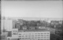
| Date: | 1930 |
|---|---|
| Description: | An elevated view of downtown Milwaukee, with Lake Michigan in the background. The eight story 1920 addition to the Boston Store is in the foreground, ident... |

| Date: | 1920 |
|---|---|
| Description: | A man is standing on the rear of a small streetcar in Japan. There is a utility pole and several two-story buildings on the left. |

| Date: | 1922 |
|---|---|
| Description: | Leonore Middleton, center left, is posing standing along a bridge railing wearing a long winter coat and hat. Other people in traditional Japanese attire a... |
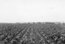
| Date: | 07 1936 |
|---|---|
| Description: | Straight rows of tobacco plants flourishing in a large field. There are farm buildings and a windmill in the background. Utility poles on the are on the ri... |
If you didn't find the material you searched for, our Library Reference Staff can help.
Call our reference desk at 608-264-6535 or email us at: