 Filter: Categories of Wisconsin Historical Images
Filter: Subject of Prairies
Filter: County of Iowa
Filter: Categories of Wisconsin Historical Images
Filter: Subject of Prairies
Filter: County of Iowa

| Date: | 1832 |
|---|---|
| Description: | This map shows lot and block numbers, as well as the location of a shot tower, houses, stores, and barns. The map is oriented with the north to the left. T... |
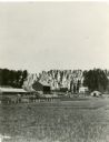
| Date: | 1886 |
|---|---|
| Description: | View across field towards a farm, with farmhouse, barn, outbuildings, and fences. The photograph appeared in Joseph Schafer's 1932 book The Wisconsin Le... |
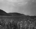
| Date: | 03 1953 |
|---|---|
| Description: | View across a prairie toward wooded hills. Caption reads: "Wisconsin River Valley. Bluffs as seen from Highway 80 west of Avoca, Wis." |
If you didn't find the material you searched for, our Library Reference Staff can help.
Call our reference desk at 608-264-6535 or email us at: