Filter: Categories of Wisconsin Historical Images
Filter: Subject of Ponds
Filter: Subject of transportation
Filter: Categories of Wisconsin Historical Images
Filter: Subject of Ponds
Filter: Subject of transportation

| Date: | 1964 |
|---|---|
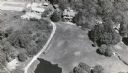
| Description: | Aerial view of the Milwaukee County Zoo grounds nearing its completion. |
| Date: | 1972 |
|---|---|
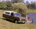
| Description: | Color advertising photograph of an International Custom 1010 pickup with a young man and woman boarding a small boat at a dock on a rural pond. |

| Date: | 1874 |
|---|---|
| Description: | Bird's-eye map of Chippewa Falls. |
| Date: | 10 23 1937 |
|---|---|
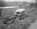
| Description: | Close-up of damaged Chevrolet in a ditch next to Highway 12 near Highway KP & Roxbury, looking north, with a farmstead in the background. |
| Date: | 07 23 1931 |
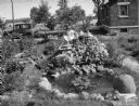
|---|---|
| Description: | Girl sitting in Arthur G. Clemens rock garden made with stones from every county in southern Wisconsin. Also includes pond, at 706 W. Lakeside Street. |
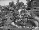
| Date: | 07 23 1931 |
|---|---|
| Description: | Girl sitting in Arthur G. Clemens rock garden made with stones from every county in southern Wisconsin. Also includes pond, 706 W. Lakeside Street. |

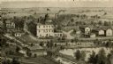
| Date: | 1879 |
|---|---|
| Description: | Bird's-eye view of Viroqua, county seat of Vernon County. |

| Date: | 1892 |
|---|---|
| Description: | Bird's-eye view of the Columbian Exposition pavilions from the vantage point of Lake Michigan. Included is an inset of the Union Passenger Station (now Uni... |
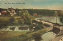
| Date: | 1905 |
|---|---|
| Description: | Elevated view of a pond, a stream, and a lake, with a road dividing the pond and stream from the lake. Industrial buildings and a smokestack are in the bac... |
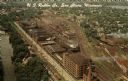
| Date: | |
|---|---|
| Description: | Aerial view of the plant, with railroad tracks along both sides of the property. A river is on the left. Several cars are parked at the plant. There is an... |
| Date: | |
|---|---|
| Description: | Elevated view of barn and farmer's house of John Bass. |

| Date: | 10 1911 |
|---|---|
| Description: | Section 1 of a Sanborn map of Osceola. |
| Date: | |
|---|---|
| Description: | An engraving based on a drawing by Alexander Simplot of the Platteville Brewery (spelled Plattville). It is an elevated perspective showing the main buildi... |
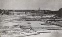
| Date: | 1866 |
|---|---|
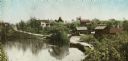
| Description: | Elevated view taken from the extreme end of Clark's Saw and Planing Mill. An old flour mill can be seen behind the bridge, and to the extreme right are thr... |

| Date: | 04 14 1974 |
|---|---|
| Description: | View of the Tenney Park bridge casting a reflection in the water of the lagoon. |

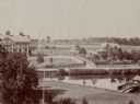
| Date: | 1913 |
|---|---|
| Description: | Panoramic view of Tenney Park showing Marston Bridge. |

| Date: | 1902 |
|---|---|
| Description: | View looking out over the lagoon in Tenney Park. |
If you didn't find the material you searched for, our Library Reference Staff can help.
Call our reference desk at 608-264-6535 or email us at: