 Filter: Categories of Wisconsin Historical Images
Filter: Subject of Parks
Filter: County of La Crosse
Filter: Categories of Wisconsin Historical Images
Filter: Subject of Parks
Filter: County of La Crosse
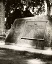
| Date: | 1939 |
|---|---|
| Description: | The Timothy Burns tablet in Burns Park, near Main Street. The tablet reads: "To perpetuate the record of the gift of Burns Park to La Crosse by Hon. Timoth... |
| Date: | 1900 |
|---|---|
| Description: | A drawing of Levee Park in La Crosse, with the Mississippi River in the foreground, and La Crosse in the background. |

| Date: | 1900 |
|---|---|
| Description: | Four-panel Panoramic view of La Crosse. Indentifiable businesses in view include: J. Hogan Wholesale Grocer, T.H. Spence Drug Co., Union Refrigerator Trans... |

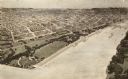
| Date: | 1910 |
|---|---|
| Description: | Caption reads: "Riverfront from Pettibone Park, La Crosse, Wis." There are three steamboats docked on the right in the harbor. A mother and her children ar... |

| Date: | 08 2000 |
|---|---|
| Description: | A man sells Gore-Lieberman buttons at Riverside Park. |

| Date: | 2004 |
|---|---|
| Description: | View from across street of a man holding Bush-Cheney '04 sign along intersection. A man next to him holds an illegible sign. |

| Date: | 2008 |
|---|---|
| Description: | A female bike rider looks over at police officer riding a horse at Riverside Park. |
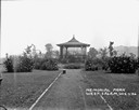
| Date: | 1926 |
|---|---|
| Description: | View down path of Memorial Park. A pavilion in the center is surrounded by bushes and plants. |

| Date: | 1931 |
|---|---|
| Description: | Relief shown by contours and spot heights. Maps shows United States, state, county and local highways and roads, schools, North Bend, creeks, lakes, rivers... |

| Date: | 1880 |
|---|---|
| Description: | This map of La Crosse shows the Chicago, Milwaukee and St. Paul Railroad, the Southern Minnesota Railroad and the Chicago, Dubuque and Minnesota Railroad, ... |

| Date: | 1893 |
|---|---|
| Description: | This map of La Crosse shows city ward boundaries in red, streets, railroads, cemeteries, Grand station crossing, the road to French Island, depots, Lake Pa... |

| Date: | 1954 |
|---|---|
| Description: | This map of La Crosse shows residential, multiple dwelling, local business, commercial, light industrial, heavy industrial and special multiple dwelling la... |

| Date: | 1972 |
|---|---|
| Description: | This map of La Crosse is a plan for the city parks and recreation areas. The cover features an explanation of the Park and Recreation plan, objectives of t... |

| Date: | 1900 |
|---|---|
| Description: | This map of La Crosse shows twenty wards, some rural lots with acreages, streets, railroads, depots, bridges, cemeteries, parks, schools, islands, and the ... |

| Date: | 1888 |
|---|---|
| Description: | This map has relief shown by hachures and features inset maps of a plat of E.D. Clinton and Blackwell’s add’n to the City of La Crosse. Wards (1-10) shaded... |

| Date: | 1927 |
|---|---|
| Description: | This map includes an index and highways marked in red. Attractions on the map include: Four Mile House, Cold Springs, Grand Crossing Station, Coleman Sloug... |

| Date: | 1883 |
|---|---|
| Description: | This map shows ward boundaries, names of additions, streets, bridges, mills, schools, religious buildings, businesses, hotels, railroads, factories, brewer... |

| Date: | 1891 |
|---|---|
| Description: | This hand-colored map shows platted additions and subdivisions, ward boundaries, schools, churches, railroads, cemeteries, parks, businesses, factories, an... |

| Date: | 1912 |
|---|---|
| Description: | This blueprint map with color manuscript annotations shows an area now known as the Forest Hills Golf Club. Includes labels for land parcels, blocks and ro... |

| Date: | 1889 |
|---|---|
| Description: | This map lists township and section numbers outside municipality, housing additions and subdivisions and plat owners outside municipality, the Black River,... |
If you didn't find the material you searched for, our Library Reference Staff can help.
Call our reference desk at 608-264-6535 or email us at: