 Filter: Categories of Wisconsin Historical Images
Filter: Subject of Ocean
Filter: Year of 1600-1699
Filter: Categories of Wisconsin Historical Images
Filter: Subject of Ocean
Filter: Year of 1600-1699

| Date: | 1655 |
|---|---|
| Description: | Christopher Columbus begins his first expedition, 1492. |

| Date: | 1655 |
|---|---|
| Description: | Encounter with Indians during Christopher Columbus' first expedition in 1492. |

| Date: | 1655 |
|---|---|
| Description: | Map from Drake Expedition, ca. 1585. |
| Date: | 1610 |
|---|---|
| Description: | A map of New France, including parts of the United States and Canada, to illustrate the Jesuit relations and allied documents. There is some handwriting an... |
| Date: | 1610 |
|---|---|
| Description: | A map of New France, including parts of the United States and Canada, to illustrate the Jesuit relations and allied documents. |

| Date: | 1698 |
|---|---|
| Description: | Copperplate engraving. Scale [ca. 1:11,500,00]. |

| Date: | 1625 |
|---|---|
| Description: | An illustrated map of the world with captions in Latin. Illustrations include depictions of the seasons and the elements. |

| Date: | 1696 |
|---|---|
| Description: | Engraved and hand-colored map of Ethiopia, from Blaeu's General Atlas. Map title is framed by a man and a woman, both wearing head turbans, who are standin... |

| Date: | 1627 |
|---|---|
| Description: | Map of North and South America showing settlements, rivers, lakes, mountains, islands and regions of the western hemisphere. It includes an inset map of Gr... |

| Date: | 1630 |
|---|---|
| Description: | One of the few maps by Dutch cartographer Willem Blaeu depicting the Americas, this map shows regions, settlements, islands, mountains, forests, rivers, an... |

| Date: | 1675 |
|---|---|
| Description: | This atlas shows the western hemisphere, with a small portion of Spain and Africa. Several place names are labeled, such as the Plymouth colony, settlement... |

| Date: | 1690 |
|---|---|
| Description: | A mysterious mixture of mythology, ancient geography, and late 17th century knowledge of the American coastline. This map shows North and South America, bu... |

| Date: | 1676 |
|---|---|
| Description: | Detailed map of North and South America. Cities, towns, forests, and mountains are shown pictorially. Duval labels regions, islands, cities, lakes, and Nat... |

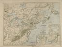
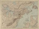
| Date: | 1679 |
|---|---|
| Description: | Decorative and detailed map of the eastern half of North America. Regions, cities, colonies, Native America land, rivers, lakes and some nautical features ... |

| Date: | 1636 |
|---|---|
| Description: | Map of North America, divided into regions, and showing some rivers, lakes, settlements, cities, mountains, and Native American land. Of the Great Lakes on... |

| Date: | 1684 |
|---|---|
| Description: | Map of North America showing some colonies, cities, rivers, lakes, and Native American land. Ship routes spread across both oceans, including one decorated... |

| Date: | 1675 |
|---|---|
| Description: | Map of the southeast coast of North America from Jamestown to modern Georgia. It shows European settlements, Native American land and villages, coastal fea... |

| Date: | 1612 |
|---|---|
| Description: | Map of New France, the area that is now eastern Canada and north eastern United States, showing lakes, rivers, and landforms. The locations of several Nati... |
If you didn't find the material you searched for, our Library Reference Staff can help.
Call our reference desk at 608-264-6535 or email us at:

