 Filter: Categories of Wisconsin Historical Images
Filter: Subject of Ocean
Filter: Categories of Wisconsin Historical Images
Filter: Subject of Ocean
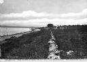
| Date: | 1908 |
|---|---|
| Description: | A view of a shoreline. Caption reads: "Part of the homestead plat and waterfront. Prudence Island." Along the left is a rock wall, and a house in the dista... |
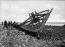
| Date: | |
|---|---|
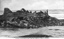
| Description: | View of part of an old boat frame, presumably from a shipwreck at Point Judith. A group of people are sitting and standing near the frame of the boat on th... |
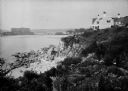
| Date: | 1930 |
|---|---|
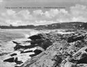
| Description: | View along top of rocky cliff toward a home on the right overlooking the ocean, with a large building further down the curving shoreline in the distance. |
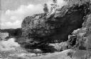
| Date: | 1940 |
|---|---|
| Description: | View of Anemone Cave and crashing waves, surrounded by coastal rock formations. |
| Date: | 1925 |
|---|---|
| Description: | View along rocky coastline with crashing waves. Buildings are along the shoreline in the distance. Caption reads: "View from Ye Headland Inn. Trefethen, Ma... |
| Date: | 1920 |
|---|---|
| Description: | View along top of cliff toward cottages along a rocky coast. A large building is in the distance on the right. |
| Date: | 1915 |
|---|---|
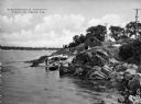
| Description: | Elevated view of a fisherman's shanty along the shoreline surrounded by rocks. At the shoreline is a man and numerous boats pulled ashore. Caption reads: "... |
| Date: | |
|---|---|
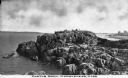
| Description: | Elevated view of Castle Rock, located on the coast, with numerous people looking out over the water. Caption reads: "Castle Rock, Marblehead, Mass." |
| Date: | |
|---|---|
| Description: | Elevated view across water toward large rocks from which people are fishing. Caption reads: "Fishing Rocks, Near Seaview, Wash." |
| Date: | |
|---|---|
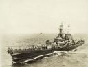
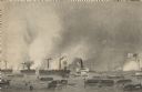
| Description: | Elevated view of the battleship U.S.S. Wisconsin on the water. Another ship is in the background near the horizon. |

| Date: | 1920 |
|---|---|
| Description: | View across harbor filled with boats toward small wooden cottages along the far shoreline. A rock wall along the water's edge is in the foreground on the r... |

| Date: | 1920 |
|---|---|
| Description: | A view of Yorks Island Harbor and lobster fishing boats in a cove. Caption reads: "Lobster Fleet at Yorks Island Harbor, Isle au Haut, Me." |
| Date: | 1920 |
|---|---|
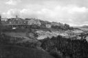
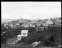
| Description: | Elevated view from hill looking down toward buildings in the hills along the coast. |
| Date: | |
|---|---|
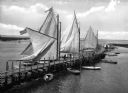
| Description: | Elevated view of a long, curving pier on the bay with large sailboats with sails out on the left side, and smaller boats on the right. |
| Date: | |
|---|---|
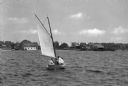
| Description: | View across water toward people on a small sailboat on Barnegat Bay, and boathouses and buildings on the far shoreline. |
| Date: | |
|---|---|
| Description: | Etching of the "Attack upon Roanoke Island" by troops landing from naval vessels, after a painting by Chappel. |

| Date: | |
|---|---|
| Description: | Elevated view of village homes on the shores of the bay with docked fishing boats in the foreground. Caption reads, "Marblehead, Mass from Rockmere Point." |

| Date: | |
|---|---|
| Description: | Hand-drawn map of the area at the time of Pilgrim landing, drawn by Charles Blaskowikz. Includes commemorative historical notes. |
| Date: | |
|---|---|
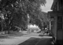
| Description: | View of Plymouth Street looking towards the waterfront with large trees along the sidewalks. |

| Date: | |
|---|---|
| Description: | Residence of Charles A. Angells. The coastline is in the background. |
If you didn't find the material you searched for, our Library Reference Staff can help.
Call our reference desk at 608-264-6535 or email us at: