 Filter: Categories of Wisconsin Historical Images
Filter: Subject of Nurseries (Horticulture)
Filter: Categories of Wisconsin Historical Images
Filter: Subject of Nurseries (Horticulture)

| Date: | 05 06 1950 |
|---|---|
| Description: | Advertising proof for International trucks, featuring color illustrations of a flatbed truck carrying lumber and a pickup truck carrying plants. Includes t... |

| Date: | 05 1935 |
|---|---|
| Description: | This Wisconsin Conservation Department map shows the locations of state forests, state nurseries, state parks, roadside parks, prison camps, and lookout to... |

| Date: | 1937 |
|---|---|
| Description: | This Wisconsin Conservation Department map shows the locations of state forests, national forests, county forests, state nurseries, Indian reservations, st... |
| Date: | |
|---|---|
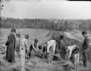
| Description: | Five men are planting a field, probably planting trees at the Lake Nursery. Behind them is a man standing near a farm building among rows of plants. Anothe... |
| Date: | |
|---|---|
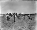
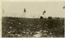
| Description: | Ten men are working in a field, probably planting raspberries at the Lake Nursery. Some of the men are standing watching. In the background are trees and h... |
| Date: | |
|---|---|
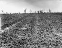
| Description: | Strawberry field, probably at the Lake Nursery. |
| Date: | |
|---|---|
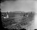
| Description: | Men, women, and children are gathered in a field picking strawberries, probably at the Lake Nursery. Castle Mound is in the distance. |
| Date: | |
|---|---|
| Description: | Man showing a carton of strawberries under an awning, while behind him men, women, and children are gathered in a field to pick strawberries, probably at t... |

| Date: | 1860 |
|---|---|
| Description: | Map showing a plat of the city, land ownership by name, wards by number, local streets, buildings, fair grounds, nurseries, and part of Rock River. The map... |

| Date: | 1911 |
|---|---|
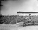
| Description: | Elevated view of garden plots at the state nursery at Trout Lake. Young pines must be grown for two years in the nursery before being planted. In this phot... |
| Date: | 05 1911 |
|---|---|
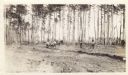
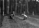
| Description: | View across field towards a number of men working to clear a field. There is a team of horses pulling a plow to create a furrow, with a pine forest in the ... |
| Date: | 1963 |
|---|---|
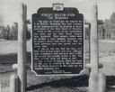
| Description: | A Wisconsin state official historical marker titled 'Forest Restoration, The Beginning.' The text reads: "This place on Trout Lake was selected by E.M. G... |

| Date: | 1911 |
|---|---|
| Description: | The first forestry building at Trout Lake Headquarters. It served the crew for eating and sleeping while they were clearing for the nursery site in progres... |
| Date: | 05 1911 |
|---|---|
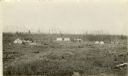
| Description: | Trout Lake was the site of the first forest planting or nursery. This camp was at the north end of Trout Lake. |
| Date: | 1914 |
|---|---|
| Description: | A view of the Lake Tomahawk ranger station taken about 1914 when the buildings were new. Shows the ranger's residence, water tower, the barn for horses wit... |
| Date: | 1911 |
|---|---|
| Description: | Cornelius L. Harrington and Ranger McNeel planting tree seedlings at the Trout Lake nursery. |

| Date: | 01 31 1950 |
|---|---|
| Description: | In this large indoor group portrait, C.L. (Neal) Harrington is in the second row, second from the right. The men are attending an operational meeting for t... |

| Date: | |
|---|---|
| Description: | Slightly elevated view of plants supported with stakes in a field. There is a water tower in the background on top of a hill on the right. People are worki... |

| Date: | 1858 |
|---|---|
| Description: | This map is hand-colored and mounted on cloth and shows lot and block numbers and dimensions, landownership, streets, railroads, selected buildings, fair g... |

| Date: | 02 1937 |
|---|---|
| Description: | This topographical map of the forest preserve shows highways, roads, trails, telephone lines, Native American reservations, Ranger sub-stations, state nurs... |
If you didn't find the material you searched for, our Library Reference Staff can help.
Call our reference desk at 608-264-6535 or email us at: