 Filter: Categories of Wisconsin Historical Images
Filter: Subject of Mounds
Filter: Categories of Wisconsin Historical Images
Filter: Subject of Mounds
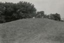
| Date: | 1939 |
|---|---|
| Description: | Burl Briggs (right), and an unknown companion pose behind a linear burial mound on the University of Wisconsin-Madison campus. |
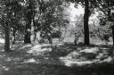
| Date: | 1939 |
|---|---|
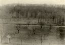
| Description: | A man poses behind a large conical Native American burial mound near the center of Picnic Point on the University of Wisconsin-Madison campus. |

| Date: | 1939 |
|---|---|
| Description: | A man poses behind a conical Native American burial mound near the west end of Picnic Point on the University of Wisconsin-Madison campus. |

| Date: | |
|---|---|
| Description: | Tapes and pins mark the locations of Native American corn hills in what is now Governor Nelson State Park. |

| Date: | 1859 |
|---|---|
| Description: | Map featuring various views of buildings and scenes from Sauk County. |
| Date: | 06 1973 |
|---|---|
| Description: | Fifth-graders from Mayville Public School celebrate the end of the school year by running down the earthen mounds at Aztalan State Park. Teachers on the tr... |
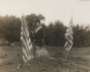
| Date: | 10 07 1914 |
|---|---|
| Description: | Sara (Mrs. Joseph) Mallon (Menominee) of Milwaukee, wearing a sash stands between two American flags behind a memorial that reads, "Indian Mounds: One of s... |

| Date: | 1828 |
|---|---|
| Description: | Plat of the Private Claims at Prairie Du Chien. |

| Date: | |
|---|---|
| Description: | Wisconsin Memorial Hospital with a key to buildings in the upper left. Indian mounds are marked on the site. Arthur Peabody was the state architect for th... |
| Date: | 1930 |
|---|---|
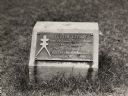
| Description: | Turtle Effigy mound marker on the University of Wisconsin-Madison campus. There is a metal plaque on a small formed block. An image of the mound is on the ... |

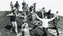
| Date: | 06 25 1899 |
|---|---|
| Description: | A group of children and adults excavating an oval mound in the Teller Group. |

| Date: | 1923 |
|---|---|
| Description: | A man in the distance stands on a mound, which is part of a group of mounds near the Fox River. Many artifacts including arrowheads and human bones have be... |
| Date: | 05 11 1894 |
|---|---|
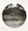
| Description: | South side view of an Indian Mound with a fence in front of it. |
| Date: | 05 11 1894 |
|---|---|
| Description: | East side view of an Indian Mound (Big Grave). |
| Date: | |
|---|---|
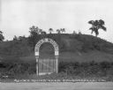
| Description: | View of a gate and sign at Monks Mound, an archaeological site. Caption reads: "Monks Mound near Edwardsville, Ill." |
| Date: | |
|---|---|
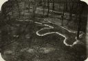
| Description: | Elevated view of Man Mound outlined in chalk looking south. A road bisects the legs of the effigy mound. A small outbuilding can be seen at left in the for... |
| Date: | |
|---|---|
| Description: | Elevated view of bear effigy mound outlined in chalk at Lake Koshkonong. |

| Date: | |
|---|---|
| Description: | Map of Baraboo and its surroundings, showing the ancient mound city, the water power, and thoroughfares, drawn by William H. Canfield. Canfield includes sk... |
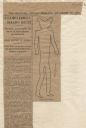
| Date: | 12 28 1906 |
|---|---|
| Description: | Newspaper article about the purchase of land for a park related to Man Mound in Sauk County accompanied by a line drawing of the mound. Article clipped fro... |
If you didn't find the material you searched for, our Library Reference Staff can help.
Call our reference desk at 608-264-6535 or email us at:
