 Filter: Categories of Wisconsin Historical Images
Filter: Subject of Mounds
Filter: Categories of Wisconsin Historical Images
Filter: Subject of Mounds

| Date: | 1864 |
|---|---|
| Description: | This map is pen and watercolor on paper and shows a profile and geological sections of the Blue Mounds, Hollow Run, Bogies Hollow Run, Bear Creek, East Bre... |

| Date: | 1864 |
|---|---|
| Description: | This map is pen and watercolor on paper and shows a profile and geological sections of the East Blue Mound Break, Blue Mound Creek, Black Earth River, and ... |

| Date: | 1864 |
|---|---|
| Description: | This map is pen and watercolor on paper and shows a profile and geological sections of the Apple River, Little Otter Creek, Woods' Branch, Bonners' Branch,... |

| Date: | 1864 |
|---|---|
| Description: | This map is pen and watercolor on paper and shows a profile and geological sections of the Spensley Break, James Break, Wisconsin River, and Little Bear Cr... |

| Date: | 1864 |
|---|---|
| Description: | This map is pen and pencil on paper and shows a profile of the Blue Mound and East Blue Mound. |

| Date: | 1864 |
|---|---|
| Description: | This map is pen and pencil on paper and shows a profile of the Blue Mound and East Blue Mound. |

| Date: | 1864 |
|---|---|
| Description: | This map shows locations of quarries, sink holes, creeks, springs, rivers, houses, forts, and roads. Annotations in pencil read: "Is the top of the mound l... |

| Date: | 1925 |
|---|---|
| Description: | This map shows trails, mounds, villages, corn fields, and contemporary civil townships; some villages and features include both Indian and English place na... |
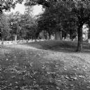
| Date: | 10 2013 |
|---|---|
| Description: | A grove of trees growing behind a line of gravestones at Forest Hill Cemetery, and what may be an effigy mound. Fallen leaves are on the grass. |

| Date: | 1900 |
|---|---|
| Description: | This photocopy map shows marshes, woods, buildings, and selected features including islands, mounds, old Fort Crawford, and "new site for a fort in questio... |

| Date: | 06 2008 |
|---|---|
| Description: | View looking east of a 1000-year-old Indian intaglio effigy in the shape of a panther. The effigy, which is on the north bank of the Rock River, is filled ... |

| Date: | 01 12 2016 |
|---|---|
| Description: | Protesters gathering at the Save the Mounds demonstration around the Capitol Square against Assembly Bill 620. A protest sign is attached to the statue "Fo... |
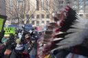
| Date: | 01 12 2016 |
|---|---|
| Description: | Save the Mounds demonstration around the Capitol Square against Assembly Bill 620. In the foreground on the right is a feather headdress worn by a tribal m... |
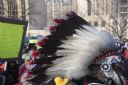
| Date: | 01 12 2016 |
|---|---|
| Description: | People gathered at the Save the Mounds demonstration around the Capitol Square against Assembly Bill 620. In the foreground is a tribal member wearing a fe... |

| Date: | 01 12 2016 |
|---|---|
| Description: | Save the Mounds demonstration at the Capitol Square against Assembly Bill 620. Flag and Standard bearers are lined up behind the speakers. In the backgroun... |

| Date: | 01 12 2016 |
|---|---|
| Description: | Save the Mounds demonstration around the Capitol Square against Assembly Bill 620. Elevated view of the protesters on the Capitol grounds looking towards S... |

| Date: | 01 12 2016 |
|---|---|
| Description: | Save the Mounds demonstration around the Capitol Square against Assembly Bill 620. View looking up at the Flag and Standard bearers lined up behind the spe... |

| Date: | 01 12 2016 |
|---|---|
| Description: | Save the Mounds demonstration around the Capitol Square against Assembly Bill 620. In the foreground, seen from behind, is a man wearing traditional dress ... |

| Date: | 01 12 2016 |
|---|---|
| Description: | Save the Mounds demonstration around the Capitol Square against Assembly Bill 620. View from behind of a man wearing traditional dress standing behind the ... |

| Date: | 01 12 2016 |
|---|---|
| Description: | Save the Mounds demonstration around the Capitol Square against Assembly Bill 620. There is a feathered eagle staff in the foreground of the image. In the ... |
If you didn't find the material you searched for, our Library Reference Staff can help.
Call our reference desk at 608-264-6535 or email us at: