 Filter: Categories of Wisconsin Historical Images
Filter: Subject of Mines and mineral resources
Filter: Community of Ashland
Filter: Categories of Wisconsin Historical Images
Filter: Subject of Mines and mineral resources
Filter: Community of Ashland

| Date: | 1885 |
|---|---|
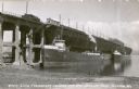
| Description: | Ore dock of the Milwaukee, Lake Shore, and Western Railroad, with a pile of logs in the foreground and docked ships in the background. |

| Date: | 1885 |
|---|---|
| Description: | View of the ore dock of the Milwaukee, Lake Shore, and Western Railroad. Large logs, buildings and a railroad bridge are in the foreground. |

| Date: | 1929 |
|---|---|
| Description: | View of an ore dock on Chequamegon Bay. Buildings on the shore of the bay can be seen, however, not the water. |

| Date: | 1920 |
|---|---|
| Description: | Caption reads: "Mammoth Ore Docks, Ashland, Wis." A building and roads are in the foreground. Several ore ships can be seen. |

| Date: | 1888 |
|---|---|
| Description: | This map shows wards and includes the Chequamegon Bay and Washburn. An inset map shows the Ashland region, its railroads, and a few of its iron mines. |

| Date: | 1985 |
|---|---|
| Description: | This map shows mining, White River, Silver Creek, Bad River, Agogic Lake, Chequamegon Bay, smaller lakes, the Bad River Indian Reservation, and communities... |
| Date: | 1935 |
|---|---|
| Description: | View from shoreline towards three ore boats at the Soo Line Railroad dock being loaded with iron ore. The first in line is the William B. Pilkey. |
If you didn't find the material you searched for, our Library Reference Staff can help.
Call our reference desk at 608-264-6535 or email us at: