 Filter: Categories of Wisconsin Historical Images
Filter: Subject of Military bases
Filter: Categories of Wisconsin Historical Images
Filter: Subject of Military bases
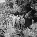
| Date: | 10 24 1943 |
|---|---|
| Description: | Three officers of General Walter Krueger's staff stand on a log in front of a swimming hole located on Goodenough Island, in the Solomon Sea, New Guinea (p... |
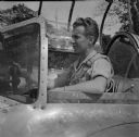
| Date: | 11 21 1943 |
|---|---|
| Description: | Major Arthur L. Post of Milwaukee, Wisconsin, was shot down on June 20th, 1943 and rescued on September 28th, 1943 after 101 days in the jungle. Here he is... |
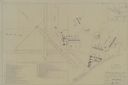
| Date: | 1947 |
|---|---|
| Description: | Map includes a legend identifying four types of runway lights for aircraft, and a building index. The map includes an inset of the site and location plan. ... |
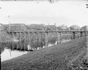
| Date: | 1918 |
|---|---|
| Description: | View down slope towards shoreline. On the opposite side of the river is an army base and portions of a small town. In the distance there is a cupola of a R... |
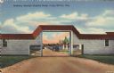
| Date: | |
|---|---|
| Description: | Colorized postcard view of an arch at Camp McCoy with ramps on either side and a road passing through it. Parked cars and barracks are on the far side of t... |

| Date: | 03 29 1960 |
|---|---|
| Description: | Wives of three airman based at Truax Field participate in an American citizenship course offered by the Truax Field Education Center. Left to right: Shie B... |

| Date: | 05 18 1960 |
|---|---|
| Description: | Three members of the Truax Field Non-Commissioned Officers Wives Club take part in the entertainment at a party of the officers and their wives. Left to ri... |

| Date: | 08 13 1960 |
|---|---|
| Description: | Russian delegates to the seventh International Soil Science Congress are greeted at Truax Municipal Airport. Ann Borland (left), Miss Madison, greets Mrs. ... |

| Date: | 09 17 1960 |
|---|---|
| Description: | People from Mexico living in the Madison area gather along with their American friends at the Truax Field Officer's Club to celebrate Mexico's Independence... |

| Date: | 09 17 1960 |
|---|---|
| Description: | People from Mexico and their Madison friends gather at the Truax Field Officer's Club to celebrate Mexico's Independence Day. Dr. Gustavo del Castillo, phy... |

| Date: | 09 17 1960 |
|---|---|
| Description: | People from Mexico and their Madison area friends gather at the Truax Field Officer's Club to celebrate Mexico Independence Day. William Rosenbaum, a frequ... |

| Date: | 08 17 1960 |
|---|---|
| Description: | People from Mexico and their Madison area friends gather at the Truax Field Officer's Club to celebrate Mexico Independence Day. Some of the Mexican women ... |

| Date: | 1959 |
|---|---|
| Description: | Night view of the northeast gate of the U.S. base at Guantanamo. |

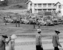
| Date: | 1965 |
|---|---|
| Description: | Large group of soldiers with packs and gear in a hangar. More packs and gear are near numbered areas in the foreground. |

| Date: | 11 1960 |
|---|---|
| Description: | View from side of road of a helicopter flying low over a hilly rural road with grass, wildflowers and trees at Guantanamo, Cuba. A chain link fence topped ... |

| Date: | 03 05 1965 |
|---|---|
| Description: | View across road towards a one-story building with three cars parked in front near the corner of E. Washington Avenue and N. Stoughton Road. The building w... |

| Date: | 1777 |
|---|---|
| Description: | Map showing the Hudson River in three sections, from New York City up through Lake Champlain, including cities, forts, roads, topographical features, and n... |
| Date: | 1967 |
|---|---|
| Description: | Men are walking in the foreground. In the background more men, in uniform, stand near several International Payscrapers parked in Phan Rang, Vietnam. Recen... |

| Date: | 1782 |
|---|---|
| Description: | Map of America east of the Mississippi River. It shows regions, state boundaries extending to the Mississippi River, cities, forts, Native American lands, ... |

| Date: | 1777 |
|---|---|
| Description: | Map of Colonial America east of Lake Michigan showing regions, cities, forts, Native American land, mountains, lakes, and rivers. Crossed swords and small ... |
If you didn't find the material you searched for, our Library Reference Staff can help.
Call our reference desk at 608-264-6535 or email us at: