Filter: Categories of Wisconsin Historical Images
Filter: Subject of Michigan, Lake
Filter: County of Racine
Filter: Categories of Wisconsin Historical Images
Filter: Subject of Michigan, Lake
Filter: County of Racine

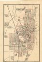
| Date: | 1874 |
|---|---|
| Description: | Bird's-eye map of Racine, with an inset of Racine College. |
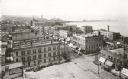
| Date: | 1898 |
|---|---|
| Description: | Elevated view of the downtown area looking northeast from the courthouse corner. |
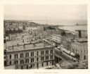
| Date: | 1888 |
|---|---|
| Description: | Elevated view from the Racine Court House of northeast Racine, with Lake Michigan on the right. Caption reads: "Bird's-Eye from Court House." |
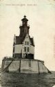
| Date: | |
|---|---|
| Description: | View of the Reef Lighthouse. Caption reads: "Racine Reef Light House, Racine, Wis." |

| Date: | 1932 |
|---|---|
| Description: | View of Lake Michigan from Memorial Hall. Caption reads: "Lake Michigan from Memorial Hall, Racine, Wisconsin". |
| Date: | 1910 |
|---|---|
| Description: | View of the main pier and harbor lighthouse from the Lake Michigan shoreline. Caption reads: "Bay and Pier, Racine, Wis." |

| Date: | 1907 |
|---|---|
| Description: | Text on front reads: "Racine, Wis. in 1850." Artist's rendering of the view of the harbor with sailing ships, sailboats, rowboats and canoes. The Main Stre... |

| Date: | |
|---|---|
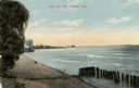
| Description: | View from Lake Michigan towards the shoreline at Racine looking southwest. |

| Date: | 1874 |
|---|---|
| Description: | Engraved view of downtown Racine seen from Lake Michigan. Several vessels are entering the harbor, and a pier with a beacon is on the right. |
| Date: | 1893 |
|---|---|
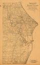
| Description: | This 1893 map of the eastern portion of Racine County, Wisconsin, shows land ownership and acreages, railroads, and roads in the towns of Caledonia and Mou... |

| Date: | 1934 |
|---|---|
| Description: | This 1934 map of Racine County, Wisconsin, shows the township and range grid, cities and villages, vegetation type, land use, roads, railroads, utilities, ... |

| Date: | |
|---|---|
| Description: | Hand-colored postcard view of the Reef Lighthouse in Lake Michigan off the shore of Racine. A person is standing to the left of the lighthouse. Caption rea... |
| Date: | |
|---|---|
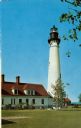
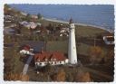
| Description: | Aerial view of Wind Point lighthouse on the shore of Lake Michigan. A few neighboring homes are in the foreground. Some of the trees are displaying fall co... |

| Date: | 1916 |
|---|---|
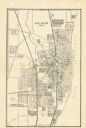
| Description: | This map of Racine includes an indexed street directory, schools, public buildings, parks, directory of buildings, and churches. The map includes 3 illustr... |

| Date: | 1921 |
|---|---|
| Description: | This map of Racine is oriented with north to the right and shows labeled streets, Lake Michigan, and points of interest. There are manuscript annotations i... |
| Date: | 1947 |
|---|---|
| Description: | This map of Racine has labeled streets, the Root River, Lake Michigan, and includes manuscript annotations of newly annexed areas and African-American neig... |

| Date: | 1956 |
|---|---|
| Description: | This map of Racine includes a street directory and index of public buildings. Streets, points of interest, Lake Michigan, and the Root River are labeled. A... |

| Date: | 1951 |
|---|---|
| Description: | This map of Racine Harbor has relief shown by contours and depths shown by gradient tints and soundings in feet. The map also shows Racine Reef, Wind Point... |
| Date: | 1950 |
|---|---|
| Description: | This map shows streets and waterways and includes annotations in red outlining wards. |
If you didn't find the material you searched for, our Library Reference Staff can help.
Call our reference desk at 608-264-6535 or email us at: